|
|
|||||||||||||||||
| Point ID: 2 | Downloads | Plots | Site Data | Code: 05AA002 |
|
|
|||||||||||||||||
| Download | |
|---|---|
| Site Descriptor Information | Site Time Series Data |
| Link to all available data | |
| View: | Time Series | All |
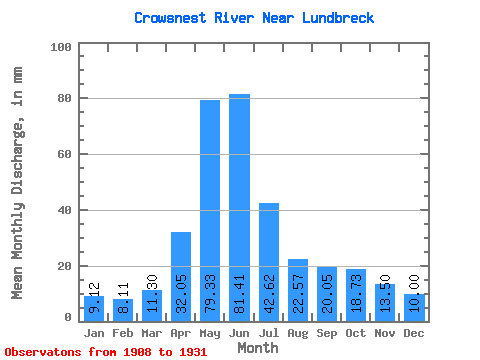
| Units: | m3/s |
| Statistic | Jan | Feb | Mar | Apr | May | Jun | Jul | Aug | Sep | Oct | Nov | Dec | Annual |
|---|---|---|---|---|---|---|---|---|---|---|---|---|---|
| Mean | 8.87 | 7.97 | 11.00 | 31.20 | 77.21 | 79.24 | 41.48 | 21.96 | 19.52 | 18.23 | 13.14 | 9.73 | 334.29 |
| Standard Deviation | 2.94 | 2.61 | 5.43 | 14.01 | 21.26 | 40.59 | 19.56 | 8.61 | 12.77 | 9.41 | 5.14 | 3.76 | 87.76 |
| Min | 4.67 | 4.98 | 5.62 | 9.09 | 16.95 | 18.60 | 14.06 | 9.67 | 9.62 | 9.19 | 7.05 | 4.95 | 200.17 |
| Max | 16.88 | 14.69 | 27.77 | 62.50 | 109.73 | 197.08 | 87.95 | 44.37 | 60.58 | 39.58 | 24.39 | 21.19 | 486.12 |
| Coefficient of Variation | 0.33 | 0.33 | 0.49 | 0.45 | 0.28 | 0.51 | 0.47 | 0.39 | 0.65 | 0.52 | 0.39 | 0.39 | 0.26 |
 Return to R-Arctic Net Home Page