|
|
|||||||||||||||||
| Point ID: 193 | Downloads | Plots | Site Data | Code: 05AH002 |
|
|
|||||||||||||||||
| Download | |
|---|---|
| Site Descriptor Information | Site Time Series Data |
| Link to all available data | |
| View: | Time Series | All |
| Units: | m3/s |
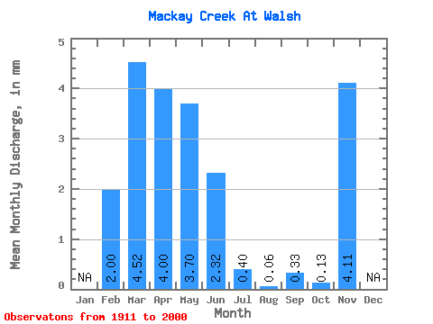
| Statistic | Jan | Feb | Mar | Apr | May | Jun | Jul | Aug | Sep | Oct | Nov | Dec | Annual |
|---|---|---|---|---|---|---|---|---|---|---|---|---|---|
| Mean | 1.99 | 4.46 | 3.96 | 3.66 | 2.30 | 0.40 | 0.06 | 0.33 | 0.13 | 4.06 | |||
| Standard Deviation | 3.92 | 5.92 | 4.70 | 7.82 | 5.91 | 1.10 | 0.34 | 1.72 | 0.45 | ||||
| Min | 0.00 | 0.00 | 0.00 | 0.00 | 0.00 | 0.00 | 0.00 | 0.00 | 0.00 | 4.06 | |||
| Max | 14.72 | 25.12 | 21.22 | 44.10 | 32.16 | 5.88 | 2.29 | 11.41 | 2.40 | 4.06 | |||
| Coefficient of Variation | 1.97 | 1.32 | 1.19 | 2.14 | 2.57 | 2.76 | 5.31 | 5.24 | 3.49 |
 Return to R-Arctic Net Home Page