|
|
|||||||||||||||||
| Point ID: 18 | Downloads | Plots | Site Data | Code: 05AA023 |
|
|
|||||||||||||||||
| Download | |
|---|---|
| Site Descriptor Information | Site Time Series Data |
| Link to all available data | |
| View: | Time Series | All |
| Units: | m3/s |
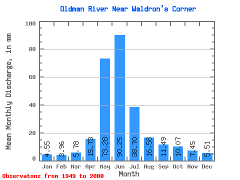
| Statistic | Jan | Feb | Mar | Apr | May | Jun | Jul | Aug | Sep | Oct | Nov | Dec | Annual |
|---|---|---|---|---|---|---|---|---|---|---|---|---|---|
| Mean | 4.55 | 4.00 | 5.78 | 15.73 | 73.27 | 90.25 | 38.69 | 16.58 | 11.49 | 10.07 | 7.45 | 5.51 | 282.85 |
| Standard Deviation | 1.26 | 0.96 | 2.80 | 8.65 | 29.85 | 44.88 | 23.15 | 11.67 | 7.33 | 4.99 | 3.77 | 2.19 | 91.86 |
| Min | 2.34 | 2.34 | 2.66 | 5.45 | 20.64 | 20.52 | 9.84 | 7.46 | 5.74 | 5.36 | 3.11 | 1.85 | 129.84 |
| Max | 7.50 | 6.98 | 14.47 | 47.34 | 150.64 | 208.80 | 121.44 | 84.06 | 51.30 | 33.10 | 24.48 | 13.02 | 501.45 |
| Coefficient of Variation | 0.28 | 0.24 | 0.48 | 0.55 | 0.41 | 0.50 | 0.60 | 0.70 | 0.64 | 0.49 | 0.51 | 0.40 | 0.33 |
 Return to R-Arctic Net Home Page