|
|
|||||||||||||||||
| Point ID: 17 | Downloads | Plots | Site Data | Code: 05AA022 |
|
|
|||||||||||||||||
| Download | |
|---|---|
| Site Descriptor Information | Site Time Series Data |
| Link to all available data | |
| View: | Time Series | All |
| Units: | m3/s |
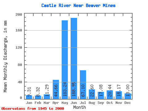
| Statistic | Jan | Feb | Mar | Apr | May | Jun | Jul | Aug | Sep | Oct | Nov | Dec | Annual |
|---|---|---|---|---|---|---|---|---|---|---|---|---|---|
| Mean | 9.31 | 8.39 | 11.29 | 44.66 | 183.21 | 188.95 | 67.09 | 22.59 | 17.08 | 20.44 | 18.17 | 13.00 | 604.62 |
| Standard Deviation | 4.02 | 4.13 | 7.71 | 23.10 | 51.90 | 86.43 | 31.98 | 9.94 | 11.77 | 16.36 | 13.12 | 8.30 | 164.46 |
| Min | 4.65 | 2.68 | 4.42 | 8.41 | 66.71 | 40.63 | 13.60 | 10.77 | 8.06 | 7.32 | 4.16 | 5.53 | 210.91 |
| Max | 23.56 | 22.71 | 50.11 | 98.26 | 303.27 | 396.83 | 151.31 | 62.80 | 80.31 | 89.81 | 66.45 | 44.25 | 1036.34 |
| Coefficient of Variation | 0.43 | 0.49 | 0.68 | 0.52 | 0.28 | 0.46 | 0.48 | 0.44 | 0.69 | 0.80 | 0.72 | 0.64 | 0.27 |
 Return to R-Arctic Net Home Page