|
|
|||||||||||||||||
| Point ID: 153 | Downloads | Plots | Site Data | Code: 05AE042 |
|
|
|||||||||||||||||
| Download | |
|---|---|
| Site Descriptor Information | Site Time Series Data |
| Link to all available data | |
| View: | Time Series | All |
| Units: | m3/s |
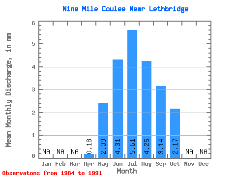
| Statistic | Jan | Feb | Mar | Apr | May | Jun | Jul | Aug | Sep | Oct | Nov | Dec | Annual |
|---|---|---|---|---|---|---|---|---|---|---|---|---|---|
| Mean | 0.19 | 2.38 | 4.31 | 5.61 | 4.25 | 3.13 | 2.16 | ||||||
| Standard Deviation | 0.20 | 1.39 | 1.53 | 1.89 | 2.15 | 1.24 | 0.78 | ||||||
| Min | 0.02 | 0.38 | 2.46 | 4.04 | 1.71 | 1.25 | 1.19 | ||||||
| Max | 0.58 | 3.92 | 7.31 | 8.70 | 7.81 | 4.90 | 3.55 | ||||||
| Coefficient of Variation | 1.07 | 0.58 | 0.36 | 0.34 | 0.51 | 0.40 | 0.36 |
 Return to R-Arctic Net Home Page