|
|
|||||||||||||||||
| Point ID: 147 | Downloads | Plots | Site Data | Code: 05AE033 |
|
|
|||||||||||||||||
| Download | |
|---|---|
| Site Descriptor Information | Site Time Series Data |
| Link to all available data | |
| View: | Time Series | All |
| Units: | m3/s |
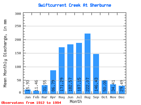
| Statistic | Jan | Feb | Mar | Apr | May | Jun | Jul | Aug | Sep | Oct | Nov | Dec | Annual |
|---|---|---|---|---|---|---|---|---|---|---|---|---|---|
| Mean | 15.93 | 11.56 | 31.55 | 86.79 | 171.26 | 182.57 | 187.12 | 222.03 | 146.44 | 49.99 | 34.41 | 29.49 | 1014.94 |
| Standard Deviation | 4.24 | 7.26 | 52.93 | 79.63 | 92.15 | 106.61 | 62.05 | 73.31 | 97.02 | 60.42 | 12.59 | 18.07 | 241.62 |
| Min | 8.88 | 2.02 | 0.00 | 0.23 | 4.94 | 7.84 | 31.88 | 34.43 | 0.08 | 0.00 | 15.89 | 14.19 | 800.65 |
| Max | 20.40 | 27.30 | 183.31 | 280.80 | 467.06 | 469.03 | 342.72 | 341.13 | 345.60 | 259.83 | 55.70 | 66.47 | 1276.80 |
| Coefficient of Variation | 0.27 | 0.63 | 1.68 | 0.92 | 0.54 | 0.58 | 0.33 | 0.33 | 0.66 | 1.21 | 0.37 | 0.61 | 0.24 |
 Return to R-Arctic Net Home Page