|
|
|||||||||||||||||
| Point ID: 146 | Downloads | Plots | Site Data | Code: 05AE032 |
|
|
|||||||||||||||||
| Download | |
|---|---|
| Site Descriptor Information | Site Time Series Data |
| Link to all available data | |
| View: | Time Series | All |
| Units: | m3/s |
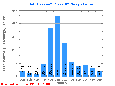
| Statistic | Jan | Feb | Mar | Apr | May | Jun | Jul | Aug | Sep | Oct | Nov | Dec | Annual |
|---|---|---|---|---|---|---|---|---|---|---|---|---|---|
| Mean | 40.52 | 27.50 | 23.82 | 96.17 | 365.70 | 449.98 | 248.20 | 110.74 | 80.67 | 87.23 | 62.90 | 40.09 | 1626.23 |
| Standard Deviation | 41.84 | 11.46 | 10.05 | 54.87 | 90.95 | 126.62 | 90.29 | 29.59 | 40.86 | 55.49 | 22.56 | 14.37 | 231.64 |
| Min | 16.14 | 13.70 | 12.41 | 28.72 | 192.95 | 176.13 | 107.12 | 62.21 | 37.99 | 24.75 | 36.71 | 21.99 | 1359.11 |
| Max | 166.67 | 52.13 | 50.90 | 309.75 | 618.77 | 747.01 | 489.03 | 194.61 | 213.80 | 228.88 | 106.26 | 66.20 | 2000.79 |
| Coefficient of Variation | 1.03 | 0.42 | 0.42 | 0.57 | 0.25 | 0.28 | 0.36 | 0.27 | 0.51 | 0.64 | 0.36 | 0.36 | 0.14 |
 Return to R-Arctic Net Home Page