|
|
|||||||||||||||||
| Point ID: 141 | Downloads | Plots | Site Data | Code: 05AE027 |
|
|
|||||||||||||||||
| Download | |
|---|---|
| Site Descriptor Information | Site Time Series Data |
| Link to all available data | |
| View: | Time Series | All |
| Units: | m3/s |
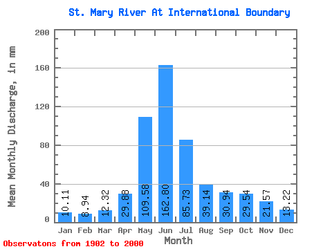
| Statistic | Jan | Feb | Mar | Apr | May | Jun | Jul | Aug | Sep | Oct | Nov | Dec | Annual |
|---|---|---|---|---|---|---|---|---|---|---|---|---|---|
| Mean | 9.77 | 8.72 | 11.91 | 28.89 | 105.94 | 157.41 | 82.88 | 37.84 | 29.92 | 28.56 | 20.86 | 12.78 | 536.64 |
| Standard Deviation | 5.76 | 4.05 | 6.53 | 14.94 | 37.34 | 78.03 | 41.16 | 15.51 | 16.90 | 16.86 | 15.05 | 7.26 | 178.24 |
| Min | 3.48 | 2.38 | 4.01 | 8.27 | 42.49 | 42.20 | 30.98 | 15.45 | 9.25 | 7.21 | 4.86 | 4.03 | 241.50 |
| Max | 45.59 | 23.39 | 32.31 | 80.76 | 223.54 | 454.14 | 217.12 | 91.41 | 91.68 | 99.59 | 86.33 | 52.90 | 1002.51 |
| Coefficient of Variation | 0.59 | 0.47 | 0.55 | 0.52 | 0.35 | 0.50 | 0.50 | 0.41 | 0.56 | 0.59 | 0.72 | 0.57 | 0.33 |
 Return to R-Arctic Net Home Page