|
|
|||||||||||||||||
| Point ID: 125 | Downloads | Plots | Site Data | Code: 05AE006 |
|
|
|||||||||||||||||
| Download | |
|---|---|
| Site Descriptor Information | Site Time Series Data |
| Link to all available data | |
| View: | Time Series | All |
| Units: | m3/s |
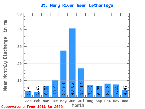
| Statistic | Jan | Feb | Mar | Apr | May | Jun | Jul | Aug | Sep | Oct | Nov | Dec | Annual |
|---|---|---|---|---|---|---|---|---|---|---|---|---|---|
| Mean | 3.50 | 3.08 | 6.45 | 9.85 | 26.19 | 38.65 | 16.25 | 6.66 | 6.39 | 7.74 | 7.24 | 4.22 | 133.48 |
| Standard Deviation | 3.94 | 2.62 | 5.55 | 8.07 | 19.32 | 32.38 | 17.18 | 8.43 | 8.90 | 8.47 | 6.78 | 3.75 | 84.63 |
| Min | 0.08 | 0.10 | 0.41 | 0.54 | 0.50 | 0.83 | 0.53 | 0.16 | 0.25 | 0.51 | 0.47 | 0.04 | 8.73 |
| Max | 27.46 | 14.79 | 28.30 | 29.52 | 81.17 | 142.45 | 86.48 | 50.98 | 46.11 | 45.14 | 32.67 | 21.55 | 391.10 |
| Coefficient of Variation | 1.13 | 0.85 | 0.86 | 0.82 | 0.74 | 0.84 | 1.06 | 1.27 | 1.39 | 1.10 | 0.94 | 0.89 | 0.63 |
 Return to R-Arctic Net Home Page