|
|
|||||||||||||||||
| Point ID: 12 | Downloads | Plots | Site Data | Code: 05AA013 |
|
|
|||||||||||||||||
| Download | |
|---|---|
| Site Descriptor Information | Site Time Series Data |
| Link to all available data | |
| View: | Time Series | All |
| Units: | m3/s |
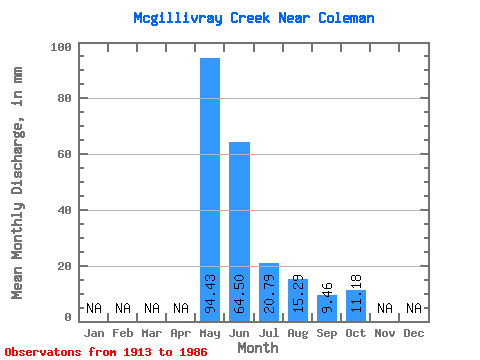
| Statistic | Jan | Feb | Mar | Apr | May | Jun | Jul | Aug | Sep | Oct | Nov | Dec | Annual |
|---|---|---|---|---|---|---|---|---|---|---|---|---|---|
| Mean | 94.40 | 64.47 | 20.82 | 15.29 | 9.45 | 11.18 | |||||||
| Standard Deviation | 50.49 | 24.79 | 11.24 | 20.21 | 4.97 | 9.11 | |||||||
| Min | 30.65 | 21.47 | 6.74 | 5.67 | 4.53 | 4.27 | |||||||
| Max | 204.61 | 99.42 | 45.44 | 78.31 | 18.37 | 36.07 | |||||||
| Coefficient of Variation | 0.54 | 0.39 | 0.54 | 1.32 | 0.53 | 0.81 |
 Return to R-Arctic Net Home Page