|
|
| Point ID: 9454 | Downloads | Plots | Site Data | Code: 15273050 |
|
| Download | |
|---|---|
| Site Descriptor Information | Site Time Series Data |
| Link to all available data | |
|
|
|
| View: | Statistics | All |
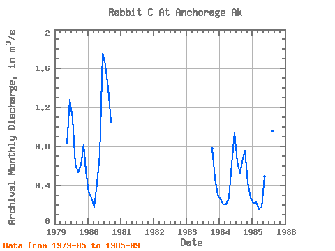
| Units: | mm |
| Year | Jan | Feb | Mar | Apr | May | Jun | Jul | Aug | Sep | Oct | Nov | Dec | Annual | 1979 | 0.83 | 1.28 | 1.09 | 0.61 | 0.53 | 0.61 | 0.82 | 0.55 | 1980 | 0.33 | 0.27 | 0.18 | 0.42 | 0.72 | 1.75 | 1.64 | 1.39 | 1.05 | 1983 | 0.78 | 0.47 | 0.30 | 1984 | 0.26 | 0.20 | 0.20 | 0.27 | 0.62 | 0.94 | 0.63 | 0.52 | 0.68 | 0.76 | 0.43 | 0.28 | 0.48 | 1985 | 0.21 | 0.23 | 0.16 | 0.18 | 0.49 | 0.90 | 1.15 | 0.96 | 1.33 |
|---|
 Return to R-Arctic Net Home Page