|
|
| Point ID: 9444 | Downloads | Plots | Site Data | Code: 15273105 |
|
| Download | |
|---|---|
| Site Descriptor Information | Site Time Series Data |
| Link to all available data | |
|
|
|
| View: | Statistics | All |
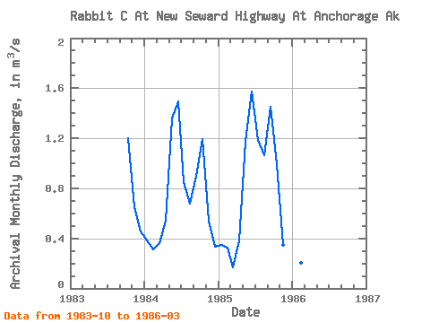
| Units: | mm |
| Year | Jan | Feb | Mar | Apr | May | Jun | Jul | Aug | Sep | Oct | Nov | Dec | Annual | 1983 | 1.20 | 0.65 | 0.46 | 1984 | 0.39 | 0.31 | 0.36 | 0.54 | 1.35 | 1.50 | 0.85 | 0.68 | 0.90 | 1.20 | 0.54 | 0.33 | 0.75 | 1985 | 0.35 | 0.32 | 0.17 | 0.39 | 1.18 | 1.57 | 1.18 | 1.06 | 1.45 | 0.99 | 0.35 | 0.41 | 0.79 | 1986 | 0.28 | 0.20 | 0.17 |
|---|
 Return to R-Arctic Net Home Page