|
|
| Point ID: 9387 | Downloads | Plots | Site Data | Code: 15746980 |
|
| Download | |
|---|---|
| Site Descriptor Information | Site Time Series Data |
| Link to all available data | |
|
|
|
| View: | Statistics | All |
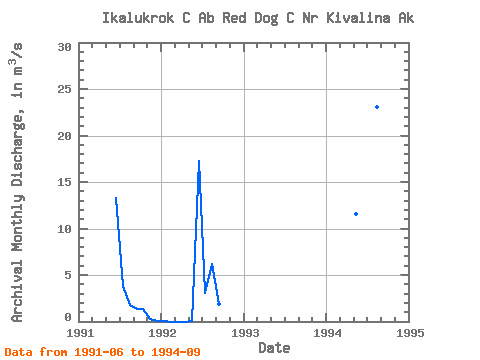
| Units: | mm |
| Year | Jan | Feb | Mar | Apr | May | Jun | Jul | Aug | Sep | Oct | Nov | Dec | Annual | 1991 | 13.31 | 3.87 | 1.76 | 1.34 | 1.38 | 0.30 | 0.02 | 1992 | 0.00 | 0.00 | 0.00 | 0.00 | 0.02 | 17.28 | 3.08 | 6.18 | 1.93 | 1994 | 11.51 | 7.01 | 9.58 | 23.12 | 4.28 |
|---|
 Return to R-Arctic Net Home Page