|
|
| Point ID: 9319 | Downloads | Plots | Site Data | Code: 15056500 |
|
| Download | |
|---|---|
| Site Descriptor Information | Site Time Series Data |
| Link to all available data | |
|
|
|
| View: | Statistics | All |
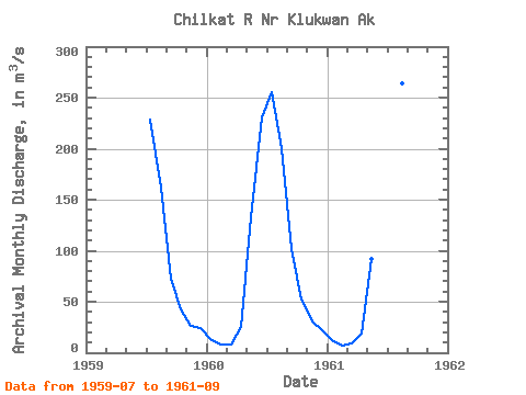
| Units: | mm |
| Year | Jan | Feb | Mar | Apr | May | Jun | Jul | Aug | Sep | Oct | Nov | Dec | Annual | 1959 | 228.93 | 161.83 | 72.61 | 42.69 | 26.08 | 24.42 | 1960 | 12.46 | 8.21 | 7.84 | 24.93 | 132.29 | 230.47 | 255.40 | 200.46 | 101.14 | 51.67 | 30.66 | 22.15 | 89.81 | 1961 | 12.71 | 7.22 | 9.46 | 18.35 | 92.40 | 238.54 | 282.16 | 263.94 | 108.52 |
|---|
 Return to R-Arctic Net Home Page