|
|
| Point ID: 9261 | Downloads | Plots | Site Data | Code: 15020000 |
|
| Download | |
|---|---|
| Site Descriptor Information | Site Time Series Data |
| Link to all available data | |
|
|
|
| View: | Statistics | All |
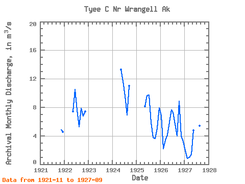
| Units: | mm |
| Year | Jan | Feb | Mar | Apr | May | Jun | Jul | Aug | Sep | Oct | Nov | Dec | Annual | 1921 | 4.87 | 4.55 | 1922 | 7.41 | 10.51 | 7.58 | 5.25 | 7.88 | 6.75 | 7.45 | 1924 | 13.29 | 11.62 | 9.55 | 6.94 | 10.97 | 1925 | 8.16 | 9.62 | 9.71 | 5.82 | 3.79 | 3.64 | 5.08 | 7.92 | 1926 | 6.80 | 2.18 | 3.44 | 4.14 | 5.95 | 7.65 | 7.25 | 5.65 | 3.98 | 8.87 | 3.96 | 3.19 | 5.25 | 1927 | 1.90 | 0.85 | 0.99 | 1.40 | 4.73 | 10.76 | 8.48 | 5.40 | 6.39 |
|---|
 Return to R-Arctic Net Home Page