|
|
| Point ID: 9253 | Downloads | Plots | Site Data | Code: 15052475 |
|
| Download | |
|---|---|
| Site Descriptor Information | Site Time Series Data |
| Link to all available data | |
|
|
|
| View: | Statistics | All |
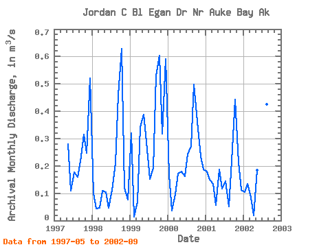
| Units: | mm |
| Year | Jan | Feb | Mar | Apr | May | Jun | Jul | Aug | Sep | Oct | Nov | Dec | Annual | 1997 | 0.28 | 0.11 | 0.18 | 0.16 | 0.22 | 0.31 | 0.25 | 0.52 | 1998 | 0.10 | 0.04 | 0.05 | 0.11 | 0.10 | 0.05 | 0.11 | 0.21 | 0.46 | 0.63 | 0.12 | 0.08 | 0.17 | 1999 | 0.32 | 0.01 | 0.07 | 0.34 | 0.39 | 0.29 | 0.15 | 0.19 | 0.53 | 0.60 | 0.32 | 0.59 | 0.32 | 2000 | 0.17 | 0.04 | 0.10 | 0.17 | 0.18 | 0.16 | 0.24 | 0.27 | 0.50 | 0.36 | 0.23 | 0.19 | 0.22 | 2001 | 0.18 | 0.15 | 0.13 | 0.06 | 0.19 | 0.12 | 0.14 | 0.05 | 0.22 | 0.44 | 0.21 | 0.11 | 0.17 | 2002 | 0.10 | 0.13 | 0.09 | 0.02 | 0.18 | 0.15 | 0.09 | 0.42 | 0.38 |
|---|
 Return to R-Arctic Net Home Page