|
|
| Point ID: 9197 | Downloads | Plots | Site Data | Code: 15237020 |
|
| Download | |
|---|---|
| Site Descriptor Information | Site Time Series Data |
| Link to all available data | |
|
|
|
| View: | Statistics | All |
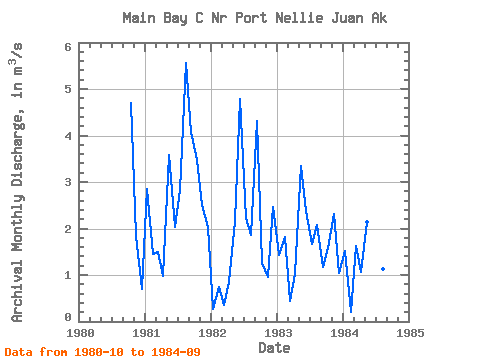
| Units: | mm |
| Year | Jan | Feb | Mar | Apr | May | Jun | Jul | Aug | Sep | Oct | Nov | Dec | Annual | 1980 | 4.70 | 1.83 | 0.71 | 1981 | 2.85 | 1.46 | 1.49 | 0.98 | 3.58 | 2.03 | 2.82 | 5.56 | 4.08 | 3.47 | 2.51 | 2.04 | 2.74 | 1982 | 0.28 | 0.73 | 0.36 | 0.85 | 2.15 | 4.78 | 2.23 | 1.86 | 4.31 | 1.25 | 0.95 | 2.46 | 1.85 | 1983 | 1.42 | 1.82 | 0.44 | 1.02 | 3.34 | 2.37 | 1.67 | 2.08 | 1.17 | 1.58 | 2.31 | 1.05 | 1.69 | 1984 | 1.52 | 0.21 | 1.63 | 1.06 | 2.15 | 1.91 | 1.46 | 1.13 | 2.88 |
|---|
 Return to R-Arctic Net Home Page