|
|
| Point ID: 7770 | Downloads | Plots | Site Data | Code: 09EB004 |
|
| Download | |
|---|---|
| Site Descriptor Information | Site Time Series Data |
| Link to all available data | |
|
|
|
| View: | Statistics | All |
| Units: | mm |
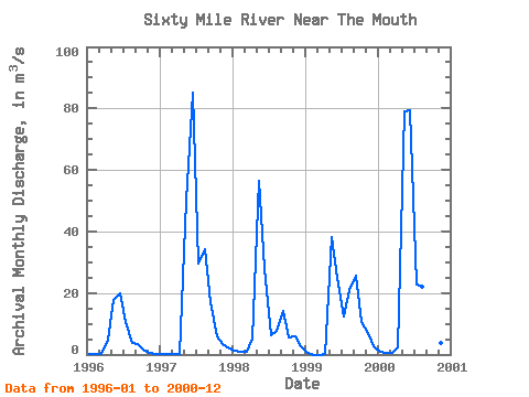
| Year | Jan | Feb | Mar | Apr | May | Jun | Jul | Aug | Sep | Oct | Nov | Dec | Annual | 1996 | 0.04 | 0.04 | 0.04 | 4.85 | 17.60 | 20.00 | 10.40 | 3.75 | 3.48 | 1.18 | 0.39 | 0.03 | 5.15 | 1997 | 0.03 | 0.03 | 0.04 | 0.20 | 50.00 | 85.00 | 29.60 | 34.30 | 17.00 | 6.07 | 3.32 | 1.84 | 18.95 | 1998 | 1.15 | 0.83 | 0.87 | 5.18 | 56.40 | 27.80 | 6.30 | 7.60 | 14.10 | 5.63 | 5.92 | 2.85 | 11.22 | 1999 | 0.55 | 0.00 | 0.00 | 0.00 | 38.00 | 25.00 | 12.50 | 20.80 | 25.50 | 10.70 | 6.99 | 2.60 | 11.89 | 2000 | 0.93 | 0.47 | 0.39 | 2.45 | 78.90 | 79.40 | 22.60 | 22.20 | 23.80 | 8.63 | 3.91 | 2.49 | 20.51 |
|---|
 Return to R-Arctic Net Home Page