|
|
| Point ID: 7283 | Downloads | Plots | Site Data | Other Close Sites | Code: 49041 |
|
| Download | |
|---|---|
| Site Descriptor Information | Site Time Series Data |
| Link to all available data | |
|
|
|
| View: | Statistics | All |
| Units: | mm |
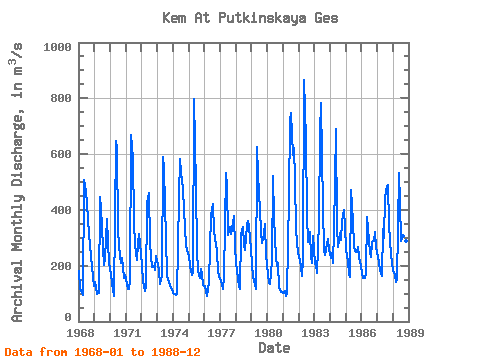
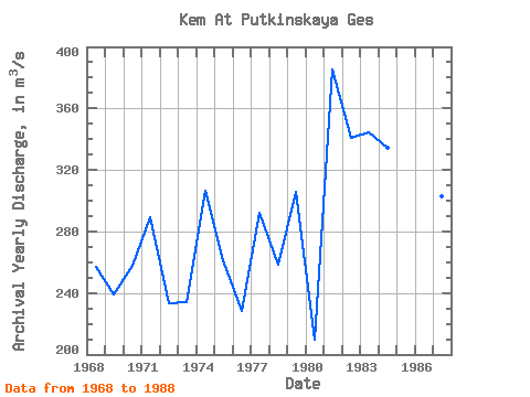
| Year | Jan | Feb | Mar | Apr | May | Jun | Jul | Aug | Sep | Oct | Nov | Dec | Annual | 1968 | 182.00 | 120.00 | 102.00 | 94.30 | 507.00 | 469.00 | 421.00 | 364.00 | 270.00 | 236.00 | 194.00 | 128.00 | 257.27 | 1969 | 141.00 | 121.00 | 97.40 | 101.00 | 448.00 | 408.00 | 262.00 | 203.00 | 229.00 | 366.00 | 283.00 | 210.00 | 239.12 | 1970 | 169.00 | 136.00 | 115.00 | 90.20 | 647.00 | 617.00 | 325.00 | 231.00 | 210.00 | 227.00 | 155.00 | 167.00 | 257.43 | 1971 | 152.00 | 115.00 | 116.00 | 146.00 | 668.00 | 585.00 | 355.00 | 275.00 | 221.00 | 277.00 | 315.00 | 245.00 | 289.17 | 1972 | 199.00 | 144.00 | 111.00 | 129.00 | 424.00 | 460.00 | 283.00 | 234.00 | 197.00 | 198.00 | 186.00 | 235.00 | 233.33 | 1973 | 204.00 | 181.00 | 133.00 | 162.00 | 590.00 | 546.00 | 294.00 | 168.00 | 149.00 | 141.00 | 121.00 | 117.00 | 233.83 | 1974 | 102.00 | 96.90 | 94.20 | 97.10 | 445.00 | 582.00 | 533.00 | 474.00 | 401.00 | 335.00 | 269.00 | 246.00 | 306.27 | 1975 | 236.00 | 199.00 | 166.00 | 176.00 | 797.00 | 481.00 | 257.00 | 182.00 | 156.00 | 187.00 | 166.00 | 131.00 | 261.17 | 1976 | 126.00 | 104.00 | 90.80 | 141.00 | 263.00 | 380.00 | 422.00 | 325.00 | 297.00 | 252.00 | 178.00 | 162.00 | 228.40 | 1977 | 146.00 | 130.00 | 115.00 | 160.00 | 533.00 | 483.00 | 310.00 | 339.00 | 312.00 | 333.00 | 379.00 | 267.00 | 292.25 | 1978 | 214.00 | 153.00 | 125.00 | 118.00 | 315.00 | 339.00 | 275.00 | 257.00 | 346.00 | 362.00 | 339.00 | 260.00 | 258.58 | 1979 | 202.00 | 159.00 | 136.00 | 118.00 | 626.00 | 526.00 | 399.00 | 322.00 | 281.00 | 314.00 | 348.00 | 240.00 | 305.92 | 1980 | 170.00 | 139.00 | 136.00 | 216.00 | 520.00 | 371.00 | 229.00 | 198.00 | 208.00 | 119.00 | 105.00 | 105.00 | 209.67 | 1981 | 103.00 | 109.00 | 90.80 | 103.00 | 450.00 | 720.00 | 748.00 | 598.00 | 623.00 | 511.00 | 327.00 | 244.00 | 385.57 | 1982 | 230.00 | 222.00 | 164.00 | 221.00 | 866.00 | 654.00 | 379.00 | 286.00 | 322.00 | 232.00 | 210.00 | 307.00 | 341.08 | 1983 | 206.00 | 207.00 | 174.00 | 357.00 | 678.00 | 783.00 | 406.00 | 255.00 | 238.00 | 276.00 | 295.00 | 258.00 | 344.42 | 1984 | 226.00 | 245.00 | 211.00 | 326.00 | 689.00 | 340.00 | 268.00 | 316.00 | 293.00 | 359.00 | 398.00 | 339.00 | 334.17 | 1985 | 259.00 | 215.00 | 170.00 | 161.00 | 473.00 | 359.00 | 267.00 | 252.00 | 250.00 | 267.00 | 232.00 | 198.00 | 258.58 | 1986 | 170.00 | 157.00 | 156.00 | 173.00 | 373.00 | 334.00 | 245.00 | 232.00 | 285.00 | 287.00 | 321.00 | 267.00 | 250.00 | 1987 | 232.00 | 208.00 | 186.00 | 162.00 | 331.00 | 301.00 | 441.00 | 487.00 | 489.00 | 347.00 | 238.00 | 210.00 | 302.67 | 1988 | 180.00 | 165.00 | 140.00 | 149.00 | 532.00 | 423.00 | 287.00 | 305.00 | 290.00 | 356.00 | 290.00 | 252.00 | 280.75 |
|---|
| Other Close Sites | ||||||
|---|---|---|---|---|---|---|
| PointID | Latitude | Longitude | Drainage Area | Source | Name | |
| 7282 | "Kem At Poduzhem'e" | 64.90 | -2287324 | SHI | 18.00 | |
 Return to R-Arctic Net Home Page