|
|
| Point ID: 692 | Downloads | Plots | Site Data | Code: 07CA901 |
|
| Download | |
|---|---|
| Site Descriptor Information | Site Time Series Data |
| Link to all available data | |
|
|
|
| View: | Statistics | All |
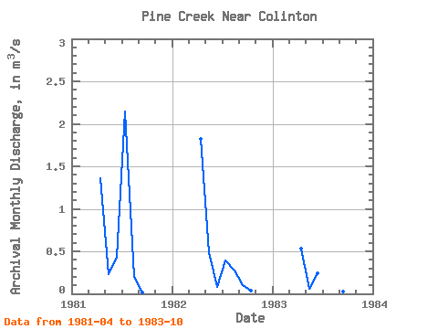
| Units: | mm |
| Year | Jan | Feb | Mar | Apr | May | Jun | Jul | Aug | Sep | Oct | Nov | Dec | Annual | 1981 | 1.36 | 0.23 | 0.44 | 2.15 | 0.20 | 0.02 | 1982 | 1.82 | 0.48 | 0.08 | 0.39 | 0.28 | 0.10 | 0.04 | 1983 | 0.53 | 0.06 | 0.24 | 0.72 | 0.08 | 0.02 | 0.04 |
|---|
 Return to R-Arctic Net Home Page