
|
|
| Point ID: 6616 | Downloads | Plots | Site Data | Code: 9392 |
|
| Download | |
|---|---|
| Site Descriptor Information | Site Time Series Data |
| Link to all available data | |
|
|
|
| View: | Statistics | All |
| Units: | mm |
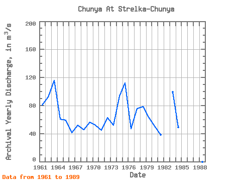
| Year | Jan | Feb | Mar | Apr | May | Jun | Jul | Aug | Sep | Oct | Nov | Dec | Annual | 1961 | 5.86 | 4.00 | 3.58 | 3.38 | 492.00 | 224.00 | 55.60 | 55.90 | 70.10 | 31.80 | 15.40 | 9.21 | 80.90 | 1962 | 5.61 | 4.80 | 4.13 | 3.68 | 448.00 | 417.00 | 47.20 | 47.20 | 60.80 | 35.80 | 17.40 | 12.10 | 91.98 | 1963 | 8.52 | 5.99 | 4.98 | 3.98 | 461.00 | 462.00 | 156.00 | 63.70 | 104.00 | 71.90 | 31.90 | 17.20 | 115.93 | 1964 | 11.80 | 8.39 | 6.15 | 5.70 | 279.00 | 141.00 | 141.00 | 58.30 | 31.70 | 21.70 | 14.10 | 7.83 | 60.56 | 1965 | 4.41 | 3.15 | 2.86 | 2.92 | 272.00 | 134.00 | 48.70 | 24.10 | 107.00 | 72.00 | 27.50 | 13.00 | 59.30 | 1966 | 7.25 | 4.37 | 2.66 | 2.20 | 324.00 | 73.00 | 27.40 | 14.10 | 13.80 | 12.90 | 8.58 | 7.43 | 41.47 | 1967 | 5.52 | 5.29 | 5.05 | 51.30 | 270.00 | 114.00 | 26.70 | 29.70 | 54.80 | 33.90 | 15.60 | 10.30 | 51.85 | 1968 | 8.22 | 6.93 | 5.16 | 12.90 | 197.00 | 67.70 | 44.80 | 33.90 | 87.50 | 50.80 | 21.10 | 10.90 | 45.58 | 1969 | 6.36 | 3.87 | 2.76 | 3.34 | 341.00 | 222.00 | 43.50 | 12.40 | 17.20 | 12.50 | 7.01 | 6.59 | 56.54 | 1970 | 5.66 | 5.86 | 5.75 | 5.16 | 281.00 | 193.00 | 36.60 | 18.90 | 29.60 | 25.50 | 10.90 | 7.12 | 52.09 | 1971 | 5.94 | 5.42 | 4.12 | 3.77 | 304.00 | 72.50 | 20.50 | 13.10 | 38.80 | 42.10 | 19.50 | 9.80 | 44.96 | 1972 | 6.34 | 4.37 | 3.71 | 3.95 | 368.00 | 231.00 | 33.50 | 24.90 | 46.80 | 17.60 | 8.84 | 6.48 | 62.96 | 1973 | 5.23 | 4.40 | 4.07 | 4.16 | 343.00 | 186.00 | 27.70 | 16.80 | 15.30 | 9.92 | 5.91 | 5.14 | 52.30 | 1974 | 4.35 | 3.28 | 2.60 | 2.84 | 207.00 | 307.00 | 67.30 | 184.00 | 203.00 | 90.80 | 34.60 | 17.60 | 93.70 | 1975 | 12.30 | 5.02 | 7.60 | 6.90 | 619.00 | 165.00 | 116.00 | 88.60 | 108.00 | 168.00 | 31.00 | 19.30 | 112.23 | 1976 | 17.90 | 10.50 | 7.67 | 7.53 | 263.00 | 156.00 | 25.20 | 20.30 | 32.00 | 13.40 | 6.57 | 6.59 | 47.22 | 1977 | 3.68 | 2.19 | 1.91 | 2.18 | 397.00 | 254.00 | 62.20 | 39.60 | 86.80 | 32.40 | 17.50 | 11.20 | 75.89 | 1978 | 8.48 | 6.53 | 4.53 | 4.66 | 563.00 | 175.00 | 44.20 | 27.80 | 39.50 | 33.50 | 21.90 | 12.70 | 78.48 | 1979 | 7.18 | 4.40 | 2.65 | 2.89 | 445.00 | 212.00 | 23.90 | 15.90 | 18.50 | 14.70 | 7.33 | 4.60 | 63.25 | 1980 | 2.57 | 0.99 | 0.91 | 1.23 | 255.00 | 200.00 | 28.10 | 32.10 | 30.30 | 29.40 | 15.80 | 7.55 | 50.33 | 1981 | 3.95 | 3.19 | 3.18 | 8.58 | 231.00 | 65.30 | 62.00 | 31.00 | 23.00 | 14.50 | 6.51 | 4.56 | 38.06 | 1982 | 2.29 | 3.19 | 537.00 | 136.00 | 39.10 | 53.70 | 30.50 | 15.80 | 10.70 | 8.72 | 1983 | 7.49 | 5.93 | 4.43 | 5.54 | 345.00 | 628.00 | 108.00 | 40.00 | 20.10 | 14.00 | 9.49 | 5.86 | 99.49 | 1984 | 5.25 | 3.61 | 3.31 | 3.20 | 373.00 | 125.00 | 25.20 | 18.10 | 15.10 | 11.80 | 5.78 | 3.90 | 49.44 | 1985 | 2.45 | 2.06 | 3.01 | 6.02 | 1986 | 3.39 | 2.79 | 2.72 | 2.61 | 220.00 | 51.80 | 9.38 | 68.10 | 61.40 | 34.90 | 14.80 | 7.57 | 39.95 | 1987 | 325.00 | 128.00 | 65.20 | 31.20 | 16.60 | 1988 | 4.14 | 282.00 | 177.00 | 84.20 | 199.00 | 124.00 | 76.90 | 57.80 | 35.60 | 1989 | 19.70 | 16.30 | 16.60 | 15.80 | 546.00 | 118.00 | 29.60 | 40.70 | 112.00 | 96.30 | 47.60 | 30.00 | 90.72 | 1993 | 236.00 | 68.30 | 48.10 | 40.70 | 1994 | 671.00 | 68.20 | 25.10 | 22.90 |
|---|
 Return to R-Arctic Net Home Page