|
|
| Point ID: 6413 | Downloads | Plots | Site Data | Code: 7053 |
|
| Download | |
|---|---|
| Site Descriptor Information | Site Time Series Data |
| Link to all available data | |
|
|
|
| View: | Statistics | All |
| Units: | mm |
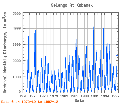
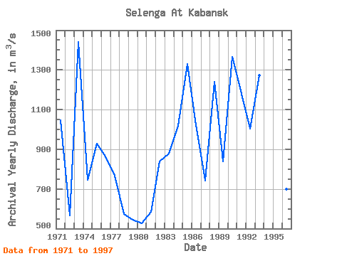
| Year | Jan | Feb | Mar | Apr | May | Jun | Jul | Aug | Sep | Oct | Nov | Dec | Annual | 1970 | 193.00 | 1971 | 120.00 | 77.80 | 60.30 | 573.00 | 1110.00 | 1770.00 | 2330.00 | 3500.00 | 1390.00 | 1040.00 | 392.00 | 185.00 | 1045.67 | 1972 | 115.00 | 70.80 | 79.40 | 476.00 | 1000.00 | 589.00 | 1180.00 | 1280.00 | 937.00 | 703.00 | 243.00 | 141.00 | 567.85 | 1973 | 83.50 | 52.80 | 55.80 | 337.00 | 1510.00 | 1720.00 | 3280.00 | 4140.00 | 3590.00 | 1720.00 | 490.00 | 303.00 | 1440.17 | 1974 | 240.00 | 133.00 | 126.00 | 663.00 | 1150.00 | 1550.00 | 1220.00 | 1430.00 | 1210.00 | 833.00 | 234.00 | 177.00 | 747.17 | 1975 | 101.00 | 73.60 | 72.00 | 530.00 | 2020.00 | 1640.00 | 2140.00 | 1850.00 | 1320.00 | 953.00 | 267.00 | 156.00 | 926.88 | 1976 | 104.00 | 74.90 | 74.50 | 327.00 | 1390.00 | 1420.00 | 1960.00 | 2270.00 | 1360.00 | 972.00 | 240.00 | 182.00 | 864.53 | 1977 | 93.90 | 53.30 | 60.50 | 523.00 | 1570.00 | 2030.00 | 1630.00 | 1470.00 | 859.00 | 604.00 | 217.00 | 107.00 | 768.14 | 1978 | 90.50 | 60.60 | 80.50 | 442.00 | 870.00 | 646.00 | 1370.00 | 999.00 | 1120.00 | 846.00 | 262.00 | 115.00 | 575.13 | 1979 | 69.40 | 47.50 | 62.70 | 232.00 | 1370.00 | 948.00 | 836.00 | 1080.00 | 856.00 | 613.00 | 286.00 | 149.00 | 545.80 | 1980 | 81.00 | 51.50 | 53.70 | 173.00 | 1460.00 | 1030.00 | 1010.00 | 950.00 | 706.00 | 524.00 | 185.00 | 112.00 | 528.02 | 1981 | 82.00 | 46.00 | 51.10 | 528.00 | 1230.00 | 817.00 | 717.00 | 1290.00 | 1250.00 | 647.00 | 186.00 | 149.00 | 582.76 | 1982 | 82.00 | 39.00 | 39.50 | 552.00 | 740.00 | 1030.00 | 2020.00 | 2240.00 | 1800.00 | 1050.00 | 295.00 | 191.00 | 839.88 | 1983 | 134.00 | 98.60 | 96.20 | 285.00 | 1170.00 | 1430.00 | 1970.00 | 2320.00 | 1500.00 | 1010.00 | 341.00 | 186.00 | 878.40 | 1984 | 115.00 | 70.20 | 65.80 | 222.00 | 1810.00 | 1660.00 | 1610.00 | 1960.00 | 2530.00 | 1500.00 | 406.00 | 255.00 | 1017.00 | 1985 | 133.00 | 91.70 | 86.30 | 602.00 | 2000.00 | 2500.00 | 2840.00 | 3350.00 | 2310.00 | 1340.00 | 414.00 | 272.00 | 1328.25 | 1986 | 196.00 | 137.00 | 132.00 | 404.00 | 1760.00 | 1930.00 | 2680.00 | 1630.00 | 1770.00 | 1060.00 | 324.00 | 230.00 | 1021.08 | 1987 | 145.00 | 120.00 | 121.00 | 472.00 | 1090.00 | 974.00 | 1130.00 | 1630.00 | 1690.00 | 1060.00 | 290.00 | 194.00 | 743.00 | 1988 | 141.00 | 92.40 | 84.90 | 444.00 | 1560.00 | 1950.00 | 2900.00 | 2660.00 | 2890.00 | 1410.00 | 486.00 | 247.00 | 1238.78 | 1989 | 206.00 | 145.00 | 121.00 | 745.00 | 959.00 | 1050.00 | 1460.00 | 1980.00 | 1580.00 | 1190.00 | 432.00 | 214.00 | 840.17 | 1990 | 142.00 | 97.20 | 114.00 | 421.00 | 1110.00 | 913.00 | 2580.00 | 4100.00 | 3710.00 | 2090.00 | 754.00 | 364.00 | 1366.27 | 1991 | 246.00 | 168.00 | 149.00 | 437.00 | 1850.00 | 1420.00 | 2620.00 | 2460.00 | 2330.00 | 1660.00 | 455.00 | 346.00 | 1178.42 | 1992 | 223.00 | 184.00 | 203.00 | 502.00 | 1670.00 | 1280.00 | 1210.00 | 1820.00 | 2640.00 | 1560.00 | 428.00 | 315.00 | 1002.92 | 1993 | 228.00 | 174.00 | 222.00 | 650.00 | 1370.00 | 1480.00 | 2100.00 | 4010.00 | 2500.00 | 1720.00 | 468.00 | 333.00 | 1271.25 | 1994 | 300.00 | 238.00 | 202.00 | 825.00 | 1100.00 | 1070.00 | 2740.00 | 2980.00 | 3050.00 | 1800.00 | 582.00 | 340.00 | 1268.92 | 1995 | 285.00 | 219.00 | 232.00 | 752.00 | 1990.00 | 2150.00 | 3010.00 | 2120.00 | 1470.00 | 1020.00 | 411.00 | 286.00 | 1162.08 | 1996 | 223.00 | 154.00 | 169.00 | 511.00 | 1200.00 | 884.00 | 1320.00 | 1630.00 | 1030.00 | 778.00 | 288.00 | 211.00 | 699.83 | 1997 | 152.00 | 115.00 | 147.00 | 695.00 | 877.00 | 1140.00 | 1050.00 | 2320.00 | 1310.00 | 925.00 | 300.00 | 170.00 | 766.75 |
|---|
 Return to R-Arctic Net Home Page