|
|
| Point ID: 5810 | Downloads | Plots | Site Data | Code: 09BC005 |
|
| Download | |
|---|---|
| Site Descriptor Information | Site Time Series Data |
| Link to all available data | |
|
|
|
| View: | Statistics | All |
| Units: | mm |
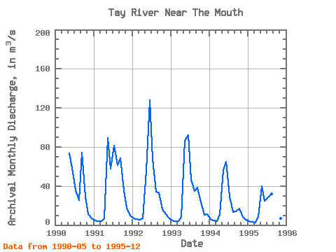
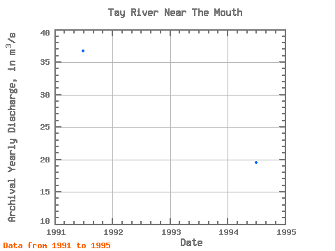
| Year | Jan | Feb | Mar | Apr | May | Jun | Jul | Aug | Sep | Oct | Nov | Dec | Annual | 1990 | 73.50 | 58.70 | 35.20 | 25.70 | 74.30 | 29.20 | 11.40 | 7.00 | 1991 | 4.93 | 4.03 | 3.80 | 6.56 | 89.30 | 58.00 | 81.40 | 61.10 | 68.30 | 35.50 | 17.40 | 10.00 | 36.69 | 1992 | 6.92 | 5.84 | 5.20 | 7.04 | 55.70 | 128.00 | 67.60 | 33.90 | 33.20 | 15.80 | 11.40 | 7.25 | 31.49 | 1993 | 4.79 | 4.00 | 3.81 | 8.19 | 86.40 | 91.90 | 45.90 | 35.10 | 38.60 | 23.10 | 10.70 | 10.80 | 30.27 | 1994 | 6.22 | 4.53 | 4.28 | 11.30 | 56.30 | 64.80 | 28.80 | 13.50 | 13.80 | 16.60 | 7.96 | 5.53 | 19.47 | 1995 | 3.97 | 3.22 | 2.79 | 8.05 | 39.80 | 24.40 | 28.60 | 31.70 | 51.70 | 20.60 | 7.16 | 6.46 | 19.04 |
|---|
 Return to R-Arctic Net Home Page