|
|
| Point ID: 5805 | Downloads | Plots | Site Data | Code: 09BB002 |
|
| Download | |
|---|---|
| Site Descriptor Information | Site Time Series Data |
| Link to all available data | |
|
|
|
| View: | Statistics | All |
| Units: | mm |
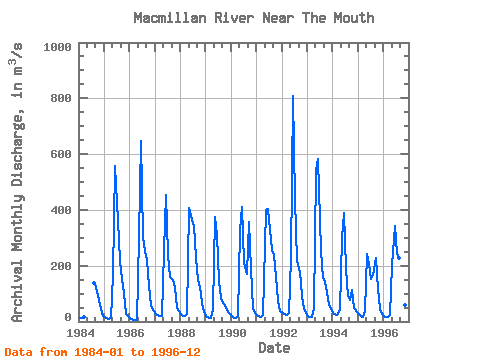
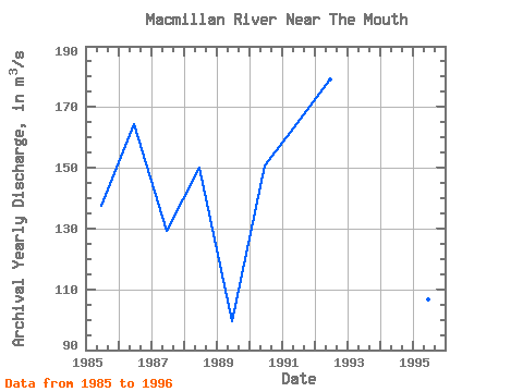
| Year | Jan | Feb | Mar | Apr | May | Jun | Jul | Aug | Sep | Oct | Nov | Dec | Annual | 1984 | 12.60 | 13.00 | 15.90 | 137.00 | 122.00 | 76.30 | 44.80 | 21.00 | 1985 | 15.70 | 11.60 | 10.10 | 14.10 | 165.00 | 556.00 | 360.00 | 216.00 | 154.00 | 102.00 | 28.20 | 18.70 | 137.62 | 1986 | 13.60 | 8.24 | 5.22 | 6.69 | 303.00 | 646.00 | 302.00 | 251.00 | 222.00 | 126.00 | 54.60 | 36.00 | 164.53 | 1987 | 25.10 | 23.40 | 18.80 | 19.80 | 254.00 | 455.00 | 240.00 | 159.00 | 147.00 | 121.00 | 49.70 | 37.40 | 129.18 | 1988 | 26.50 | 21.00 | 19.20 | 25.70 | 406.00 | 365.00 | 341.00 | 227.00 | 148.00 | 123.00 | 64.70 | 32.30 | 149.95 | 1989 | 20.00 | 14.20 | 12.20 | 45.10 | 376.00 | 311.00 | 144.00 | 84.70 | 67.40 | 59.10 | 33.30 | 26.30 | 99.44 | 1990 | 18.70 | 13.80 | 13.10 | 21.40 | 326.00 | 411.00 | 211.00 | 169.00 | 357.00 | 189.00 | 50.00 | 28.80 | 150.73 | 1991 | 21.70 | 19.70 | 17.50 | 23.20 | 399.00 | 402.00 | 328.00 | 255.00 | 238.00 | 160.00 | 73.60 | 39.10 | 164.73 | 1992 | 31.10 | 25.90 | 22.50 | 29.60 | 229.00 | 809.00 | 438.00 | 217.00 | 178.00 | 91.80 | 44.80 | 31.30 | 179.00 | 1993 | 21.10 | 17.80 | 17.60 | 48.80 | 541.00 | 583.00 | 254.00 | 155.00 | 141.00 | 105.00 | 59.40 | 47.10 | 165.90 | 1994 | 31.90 | 23.50 | 21.90 | 42.60 | 299.00 | 388.00 | 188.00 | 93.10 | 76.50 | 114.00 | 47.70 | 35.70 | 113.49 | 1995 | 26.00 | 19.70 | 16.00 | 36.30 | 242.00 | 205.00 | 154.00 | 167.00 | 228.00 | 116.00 | 44.60 | 25.60 | 106.68 | 1996 | 19.40 | 17.30 | 16.40 | 22.00 | 204.00 | 343.00 | 242.00 | 226.00 | 217.00 | 97.00 | 58.10 | 39.50 | 125.14 |
|---|
 Return to R-Arctic Net Home Page