|
|
| Point ID: 5605 | Downloads | Plots | Site Data | Other Close Sites | Code: 06EA010 |
|
| Download | |
|---|---|
| Site Descriptor Information | Site Time Series Data |
| Link to all available data | |
|
|
|
| View: | Statistics | All |
| Units: | mm |
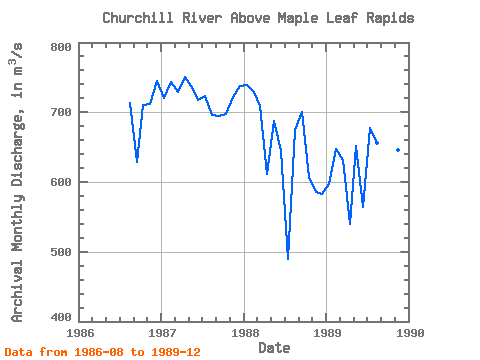
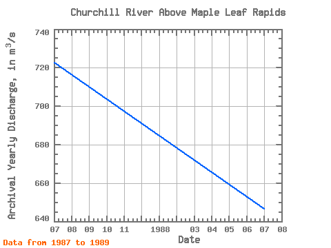
| Year | Jan | Feb | Mar | Apr | May | Jun | Jul | Aug | Sep | Oct | Nov | Dec | Annual | 1986 | 713.00 | 628.00 | 710.00 | 712.00 | 745.00 | 1987 | 721.00 | 744.00 | 729.00 | 751.00 | 738.00 | 718.00 | 724.00 | 696.00 | 695.00 | 697.00 | 722.00 | 737.00 | 722.67 | 1988 | 739.00 | 729.00 | 709.00 | 612.00 | 687.00 | 645.00 | 489.00 | 674.00 | 700.00 | 607.00 | 586.00 | 583.00 | 646.67 | 1989 | 597.00 | 648.00 | 632.00 | 540.00 | 652.00 | 564.00 | 678.00 | 656.00 | 617.00 | 669.00 | 646.00 | 693.00 | 632.67 |
|---|
| Other Close Sites | ||||||
|---|---|---|---|---|---|---|
| PointID | Latitude | Longitude | Drainage Area | Source | Name | |
| 5603 | "CHURCHILL RIVER AT SANDY BAY" | 55.52 | 805163 | Hydat | ||
 Return to R-Arctic Net Home Page