|
|
| Point ID: 5390 | Downloads | Plots | Site Data | Code: 05JJ002 |
|
| Download | |
|---|---|
| Site Descriptor Information | Site Time Series Data |
| Link to all available data | |
|
|
|
| View: | Statistics | All |
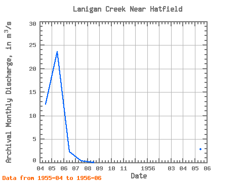
| Units: | mm |
| Year | Jan | Feb | Mar | Apr | May | Jun | Jul | Aug | Sep | Oct | Nov | Dec | Annual | 1955 | 12.40 | 23.60 | 2.27 | 0.36 | 0.03 | 1956 | 8.92 | 2.90 | 0.85 |
|---|
 Return to R-Arctic Net Home Page