|
|
| Point ID: 5347 | Downloads | Plots | Site Data | Code: 05JB005 |
|
| Download | |
|---|---|
| Site Descriptor Information | Site Time Series Data |
| Link to all available data | |
|
|
|
| View: | Statistics | All |
| Units: | mm |
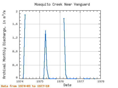
| Year | Jan | Feb | Mar | Apr | May | Jun | Jul | Aug | Sep | Oct | Nov | Dec | Annual | 1974 | 0.00 | 1.87 | 1975 | 0.00 | 1.41 | 0.27 | 0.00 | 0.00 | 0.00 | 0.00 | 0.00 | 1976 | 1.76 | 0.13 | 0.00 | 0.00 | 0.00 | 0.00 | 0.00 | 0.00 | 1977 | 0.00 | 0.00 | 0.00 | 0.00 | 0.00 | 0.00 | 0.00 | 0.00 |
|---|
 Return to R-Arctic Net Home Page