|

|
| Point ID: 5169 | Downloads | Plots | Site Data | Code: 03JB004 |
|
| Download | |
|---|---|
| Site Descriptor Information | Site Time Series Data |
| Link to all available data | |
|
|
|
| View: | Statistics | All |
| Units: | mm |
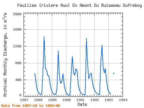
| Year | Jan | Feb | Mar | Apr | May | Jun | Jul | Aug | Sep | Oct | Nov | Dec | Annual | 1987 | 545.00 | 337.00 | 188.00 | 1988 | 108.00 | 68.90 | 51.80 | 48.40 | 563.00 | 1430.00 | 669.00 | 636.00 | 504.00 | 491.00 | 300.00 | 163.00 | 419.43 | 1989 | 90.30 | 62.30 | 50.80 | 44.40 | 190.00 | 1090.00 | 479.00 | 311.00 | 356.00 | 541.00 | 274.00 | 138.00 | 302.23 | 1990 | 73.90 | 46.80 | 35.40 | 32.10 | 509.00 | 955.00 | 574.00 | 503.00 | 666.00 | 609.00 | 280.00 | 145.00 | 369.10 | 1991 | 88.50 | 62.10 | 47.30 | 40.70 | 44.00 | 1390.00 | 759.00 | 417.00 | 518.00 | 552.00 | 348.00 | 209.00 | 372.97 | 1992 | 135.00 | 95.00 | 70.50 | 54.60 | 44.70 | 843.00 | 1220.00 | 661.00 | 562.00 | 673.00 | 387.00 | 192.00 | 411.48 | 1993 | 104.00 | 65.00 | 46.10 | 37.60 | 548.00 | 1220.00 |
|---|
 Return to R-Arctic Net Home Page