|
|
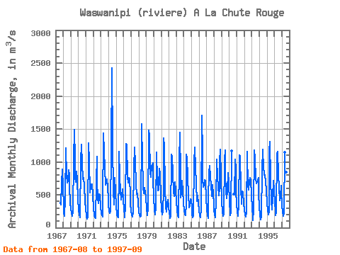
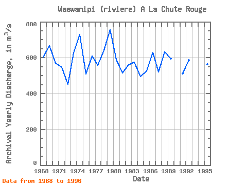
| Point ID: 5080 | Downloads | Plots | Site Data | Code: 03AB002 |
|
| Download | |
|---|---|
| Site Descriptor Information | Site Time Series Data |
| Link to all available data | |
|
|
|
| View: | Statistics | All |
| Units: | mm |
| Year | Jan | Feb | Mar | Apr | May | Jun | Jul | Aug | Sep | Oct | Nov | Dec | Annual | 1967 | 382.00 | 354.00 | 677.00 | 885.00 | 605.00 | 1968 | 336.00 | 226.00 | 174.00 | 451.00 | 1210.00 | 794.00 | 678.00 | 705.00 | 877.00 | 803.00 | 617.00 | 383.00 | 604.50 | 1969 | 288.00 | 224.00 | 180.00 | 252.00 | 1040.00 | 1490.00 | 1050.00 | 762.00 | 695.00 | 852.00 | 725.00 | 432.00 | 665.83 | 1970 | 260.00 | 195.00 | 161.00 | 179.00 | 1010.00 | 1260.00 | 969.00 | 739.00 | 758.00 | 633.00 | 404.00 | 275.00 | 570.25 | 1971 | 194.00 | 166.00 | 138.00 | 169.00 | 1280.00 | 1020.00 | 528.00 | 631.00 | 620.00 | 663.00 | 666.00 | 492.00 | 547.25 | 1972 | 302.00 | 193.00 | 156.00 | 150.00 | 695.00 | 1080.00 | 729.00 | 435.00 | 368.00 | 515.00 | 495.00 | 302.00 | 451.67 | 1973 | 217.00 | 184.00 | 172.00 | 321.00 | 1440.00 | 1160.00 | 897.00 | 649.00 | 681.00 | 740.00 | 608.00 | 451.00 | 626.67 | 1974 | 334.00 | 255.00 | 223.00 | 255.00 | 1210.00 | 2430.00 | 1260.00 | 563.00 | 347.00 | 570.00 | 754.00 | 553.00 | 729.50 | 1975 | 328.00 | 204.00 | 163.00 | 153.00 | 868.00 | 1160.00 | 775.00 | 549.00 | 425.00 | 487.00 | 582.00 | 427.00 | 510.08 | 1976 | 271.00 | 188.00 | 157.00 | 344.00 | 1270.00 | 1250.00 | 780.00 | 685.00 | 758.00 | 736.00 | 510.00 | 367.00 | 609.67 | 1977 | 255.00 | 197.00 | 172.00 | 226.00 | 896.00 | 1220.00 | 977.00 | 691.00 | 653.00 | 509.00 | 520.00 | 379.00 | 557.92 | 1978 | 240.00 | 183.00 | 167.00 | 176.00 | 1580.00 | 1510.00 | 1090.00 | 616.00 | 519.00 | 611.00 | 533.00 | 473.00 | 641.50 | 1979 | 277.00 | 208.00 | 184.00 | 295.00 | 1480.00 | 1390.00 | 836.00 | 767.00 | 936.00 | 952.00 | 982.00 | 756.00 | 755.25 | 1980 | 444.00 | 269.00 | 197.00 | 312.00 | 1150.00 | 724.00 | 568.00 | 574.00 | 652.00 | 899.00 | 824.00 | 473.00 | 590.50 | 1981 | 274.00 | 204.00 | 250.00 | 555.00 | 1360.00 | 1240.00 | 619.00 | 313.00 | 247.00 | 368.00 | 423.00 | 322.00 | 514.58 | 1982 | 223.00 | 185.00 | 150.00 | 174.00 | 1110.00 | 1080.00 | 824.00 | 557.00 | 478.00 | 649.00 | 695.00 | 565.00 | 557.50 | 1983 | 392.00 | 263.00 | 174.00 | 161.00 | 1010.00 | 1450.00 | 808.00 | 459.00 | 524.00 | 712.00 | 554.00 | 383.00 | 574.17 | 1984 | 261.00 | 204.00 | 185.00 | 365.00 | 1110.00 | 1050.00 | 765.00 | 500.00 | 311.00 | 338.00 | 431.00 | 420.00 | 495.00 | 1985 | 300.00 | 205.00 | 157.00 | 174.00 | 997.00 | 1220.00 | 907.00 | 669.00 | 407.00 | 410.00 | 489.00 | 375.00 | 525.83 | 1986 | 261.00 | 186.00 | 153.00 | 289.00 | 1700.00 | 1100.00 | 724.00 | 619.00 | 645.00 | 726.00 | 708.00 | 448.00 | 629.92 | 1987 | 287.00 | 183.00 | 143.00 | 437.00 | 831.00 | 937.00 | 773.00 | 653.00 | 482.00 | 649.00 | 512.00 | 369.00 | 521.33 | 1988 | 272.00 | 203.00 | 157.00 | 427.00 | 1040.00 | 767.00 | 621.00 | 494.00 | 605.00 | 1010.00 | 1190.00 | 787.00 | 631.08 | 1989 | 392.00 | 247.00 | 182.00 | 199.00 | 1040.00 | 1180.00 | 801.00 | 554.00 | 451.00 | 567.00 | 835.00 | 695.00 | 595.25 | 1990 | 383.00 | 237.00 | 190.00 | 246.00 | 1170.00 | 509.00 | 497.00 | 1040.00 | 899.00 | 555.00 | 1991 | 363.00 | 244.00 | 177.00 | 349.00 | 1100.00 | 1080.00 | 614.00 | 356.00 | 412.00 | 553.00 | 529.00 | 374.00 | 512.58 | 1992 | 274.00 | 202.00 | 167.00 | 226.00 | 1160.00 | 1120.00 | 639.00 | 576.00 | 703.00 | 756.00 | 715.00 | 503.00 | 586.75 | 1993 | 285.00 | 176.00 | 118.00 | 276.00 | 1180.00 | 1050.00 | 747.00 | 668.00 | 706.00 | 713.00 | 758.00 | 516.00 | 599.42 | 1994 | 314.00 | 196.00 | 129.00 | 176.00 | 877.00 | 1190.00 | 884.00 | 853.00 | 797.00 | 801.00 | 694.00 | 574.00 | 623.75 | 1995 | 376.00 | 261.00 | 197.00 | 253.00 | 1170.00 | 1310.00 | 742.00 | 419.00 | 279.00 | 452.00 | 718.00 | 576.00 | 562.75 | 1996 | 367.00 | 259.00 | 185.00 | 233.00 | 1110.00 | 1160.00 | 800.00 | 606.00 | 409.00 | 466.00 | 640.00 | 560.00 | 566.25 | 1997 | 339.00 | 241.00 | 178.00 | 235.00 | 1150.00 | 1330.00 | 1170.00 | 844.00 | 554.00 |
|---|
 Return to R-Arctic Net Home Page