|
|
| Point ID: 4432 | Downloads | Plots | Site Data | Code: 05QB007 |
|
| Download | |
|---|---|
| Site Descriptor Information | Site Time Series Data |
| Link to all available data | |
|
|
|
| View: | Statistics | All |
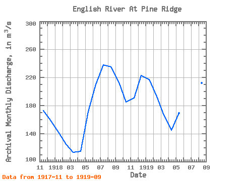
| Units: | mm |
| Year | Jan | Feb | Mar | Apr | May | Jun | Jul | Aug | Sep | Oct | Nov | Dec | Annual | 1917 | 173.00 | 159.00 | 1918 | 142.00 | 125.00 | 113.00 | 115.00 | 171.00 | 210.00 | 238.00 | 235.00 | 213.00 | 185.00 | 191.00 | 223.00 | 180.08 | 1919 | 217.00 | 193.00 | 166.00 | 145.00 | 169.00 | 203.00 | 219.00 | 212.00 | 216.00 |
|---|
 Return to R-Arctic Net Home Page