|
|
| Point ID: 4389 | Downloads | Plots | Site Data | Code: 05PB004 |
|
| Download | |
|---|---|
| Site Descriptor Information | Site Time Series Data |
| Link to all available data | |
|
|
|
| View: | Statistics | All |
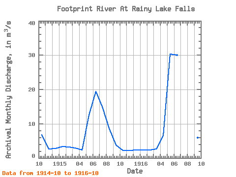
| Units: | mm |
| Year | Jan | Feb | Mar | Apr | May | Jun | Jul | Aug | Sep | Oct | Nov | Dec | Annual | 1914 | 6.75 | 2.61 | 2.86 | 1915 | 3.30 | 3.24 | 2.91 | 2.39 | 12.50 | 19.40 | 15.00 | 8.63 | 3.83 | 2.19 | 2.27 | 2.35 | 6.50 | 1916 | 2.35 | 2.35 | 2.60 | 6.49 | 30.30 | 30.00 | 16.80 | 9.18 | 6.00 | 3.76 |
|---|
 Return to R-Arctic Net Home Page