
|
|
| Point ID: 4381 | Downloads | Plots | Site Data | Other Close Sites | Code: 04ME003 |
|
| Download | |
|---|---|
| Site Descriptor Information | Site Time Series Data |
| Link to all available data | |
|
|
|
| View: | Statistics | All |
| Units: | mm |
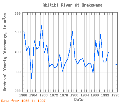
| Year | Jan | Feb | Mar | Apr | May | Jun | Jul | Aug | Sep | Oct | Nov | Dec | Annual | 1959 | 420.00 | 288.00 | 271.00 | 1960 | 266.00 | 264.00 | 298.00 | 468.00 | 2050.00 | 691.00 | 385.00 | 338.00 | 262.00 | 380.00 | 388.00 | 278.00 | 505.67 | 1961 | 274.00 | 203.00 | 227.00 | 504.00 | 795.00 | 415.00 | 354.00 | 190.00 | 622.00 | 573.00 | 433.00 | 321.00 | 409.25 | 1962 | 320.00 | 352.00 | 331.00 | 460.00 | 1040.00 | 713.00 | 279.00 | 336.00 | 570.00 | 298.00 | 241.00 | 209.00 | 429.08 | 1963 | 156.00 | 152.00 | 163.00 | 415.00 | 566.00 | 402.00 | 216.00 | 223.00 | 228.00 | 223.00 | 225.00 | 221.00 | 265.83 | 1964 | 227.00 | 221.00 | 215.00 | 719.00 | 1020.00 | 912.00 | 439.00 | 304.00 | 291.00 | 515.00 | 375.00 | 249.00 | 457.25 | 1965 | 207.00 | 229.00 | 245.00 | 245.00 | 1200.00 | 367.00 | 337.00 | 306.00 | 444.00 | 741.00 | 390.00 | 258.00 | 414.08 | 1966 | 244.00 | 276.00 | 255.00 | 523.00 | 833.00 | 515.00 | 271.00 | 252.00 | 252.00 | 750.00 | 509.00 | 416.00 | 424.67 | 1967 | 325.00 | 406.00 | 382.00 | 815.00 | 1810.00 | 865.00 | 304.00 | 305.00 | 252.00 | 289.00 | 350.00 | 313.00 | 534.67 | 1968 | 260.00 | 266.00 | 303.00 | 728.00 | 419.00 | 356.00 | 695.00 | 384.00 | 392.00 | 354.00 | 304.00 | 280.00 | 395.08 | 1969 | 260.00 | 237.00 | 242.00 | 471.00 | 758.00 | 551.00 | 355.00 | 350.00 | 396.00 | 638.00 | 583.00 | 388.00 | 435.75 | 1970 | 303.00 | 292.00 | 276.00 | 351.00 | 657.00 | 458.00 | 329.00 | 244.00 | 374.00 | 206.00 | 204.00 | 230.00 | 327.00 | 1971 | 200.00 | 226.00 | 259.00 | 423.00 | 972.00 | 321.00 | 241.00 | 228.00 | 369.00 | 288.00 | 312.00 | 252.00 | 340.92 | 1972 | 219.00 | 265.00 | 264.00 | 252.00 | 831.00 | 468.00 | 300.00 | 229.00 | 208.00 | 339.00 | 257.00 | 227.00 | 321.58 | 1973 | 217.00 | 216.00 | 265.00 | 489.00 | 737.00 | 332.00 | 323.00 | 290.00 | 288.00 | 288.00 | 277.00 | 243.00 | 330.42 | 1974 | 208.00 | 217.00 | 258.00 | 307.00 | 1020.00 | 619.00 | 426.00 | 303.00 | 276.00 | 394.00 | 364.00 | 295.00 | 390.58 | 1975 | 255.00 | 249.00 | 250.00 | 338.00 | 715.00 | 465.00 | 253.00 | 202.00 | 183.00 | 182.00 | 315.00 | 246.00 | 304.42 | 1976 | 222.00 | 205.00 | 202.00 | 825.00 | 781.00 | 346.00 | 228.00 | 246.00 | 267.00 | 295.00 | 271.00 | 220.00 | 342.33 | 1977 | 234.00 | 219.00 | 255.00 | 1000.00 | 550.00 | 275.00 | 286.00 | 230.00 | 418.00 | 280.00 | 370.00 | 236.00 | 362.75 | 1978 | 213.00 | 210.00 | 177.00 | 219.00 | 1150.00 | 822.00 | 643.00 | 263.00 | 287.00 | 468.00 | 268.00 | 244.00 | 413.67 | 1979 | 249.00 | 260.00 | 220.00 | 674.00 | 1570.00 | 963.00 | 347.00 | 285.00 | 323.00 | 486.00 | 384.00 | 299.00 | 505.00 | 1980 | 303.00 | 287.00 | 249.00 | 613.00 | 824.00 | 392.00 | 240.00 | 236.00 | 268.00 | 428.00 | 305.00 | 237.00 | 365.17 | 1981 | 230.00 | 252.00 | 283.00 | 682.00 | 834.00 | 431.00 | 259.00 | 198.00 | 211.00 | 245.00 | 248.00 | 197.00 | 339.17 | 1982 | 176.00 | 221.00 | 202.00 | 316.00 | 880.00 | 257.00 | 360.00 | 224.00 | 322.00 | 576.00 | 506.00 | 315.00 | 362.92 | 1983 | 269.00 | 255.00 | 224.00 | 280.00 | 1140.00 | 606.00 | 228.00 | 203.00 | 346.00 | 344.00 | 277.00 | 234.00 | 367.17 | 1984 | 213.00 | 221.00 | 214.00 | 616.00 | 426.00 | 492.00 | 485.00 | 229.00 | 195.00 | 218.00 | 285.00 | 318.00 | 326.00 | 1985 | 285.00 | 283.00 | 282.00 | 613.00 | 612.00 | 283.00 | 331.00 | 258.00 | 215.00 | 286.00 | 355.00 | 295.00 | 341.50 | 1986 | 259.00 | 253.00 | 257.00 | 594.00 | 635.00 | 269.00 | 233.00 | 370.00 | 275.00 | 402.00 | 317.00 | 288.00 | 346.00 | 1987 | 274.00 | 290.00 | 247.00 | 394.00 | 287.00 | 296.00 | 270.00 | 283.00 | 218.00 | 378.00 | 320.00 | 281.00 | 294.83 | 1988 | 281.00 | 272.00 | 304.00 | 561.00 | 1160.00 | 330.00 | 257.00 | 462.00 | 349.00 | 379.00 | 757.00 | 381.00 | 457.75 | 1989 | 269.00 | 265.00 | 227.00 | 309.00 | 1150.00 | 691.00 | 302.00 | 301.00 | 164.00 | 257.00 | 341.00 | 302.00 | 381.50 | 1990 | 266.00 | 272.00 | 352.00 | 740.00 | 1060.00 | 458.00 | 562.00 | 341.00 | 327.00 | 634.00 | 502.00 | 347.00 | 488.42 | 1991 | 355.00 | 336.00 | 294.00 | 701.00 | 593.00 | 267.00 | 213.00 | 195.00 | 300.00 | 406.00 | 308.00 | 229.00 | 349.75 | 1992 | 227.00 | 224.00 | 212.00 | 478.00 | 911.00 | 255.00 | 233.00 | 238.00 | 368.00 | 438.00 | 352.00 | 262.00 | 349.83 | 1993 | 234.00 | 223.00 | 232.00 | 409.00 | 836.00 | 623.00 | 350.00 | 393.00 | 468.00 | 419.00 | 354.00 | 240.00 | 398.42 | 1994 | 234.00 | 256.00 | 215.00 | 349.00 | 499.00 | 452.00 | 375.00 | 446.00 | 289.00 | 314.00 | 334.00 | 280.00 | 336.92 | 1995 | 245.00 | 255.00 | 275.00 | 328.00 | 751.00 | 385.00 | 242.00 | 208.00 | 166.00 | 434.00 | 350.00 | 235.00 | 322.83 | 1996 | 179.00 | 187.00 | 185.00 | 177.00 | 1510.00 | 420.00 | 318.00 | 194.00 | 152.00 | 232.00 | 303.00 | 202.00 | 338.25 | 1997 | 269.00 | 271.00 | 214.00 | 617.00 | 947.00 | 271.00 | 314.00 | 165.00 | 153.00 | 167.00 | 300.00 | 253.00 | 328.42 |
|---|
| Other Close Sites | ||||||
|---|---|---|---|---|---|---|
| PointID | Latitude | Longitude | Drainage Area | Source | Name | |
| 4367 | "MOOSE RIVER AT MOOSE RIVER" | 50.81 | -647140 | Hydat | ||
| 4369 | "MOOSE RIVER ABOVE MOOSE RIVER" | 50.74 | -636431 | Hydat | ||
 Return to R-Arctic Net Home Page