|
|
| Point ID: 4379 | Downloads | Plots | Site Data | Code: 04ME001 |
|
| Download | |
|---|---|
| Site Descriptor Information | Site Time Series Data |
| Link to all available data | |
|
|
|
| View: | Statistics | All |
| Units: | mm |
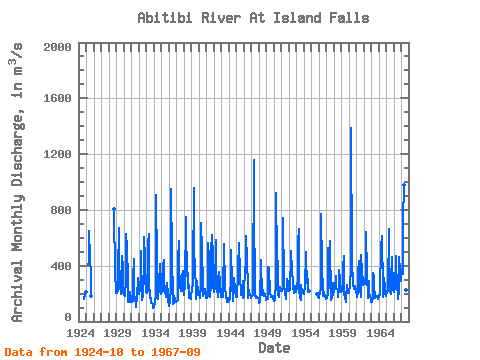
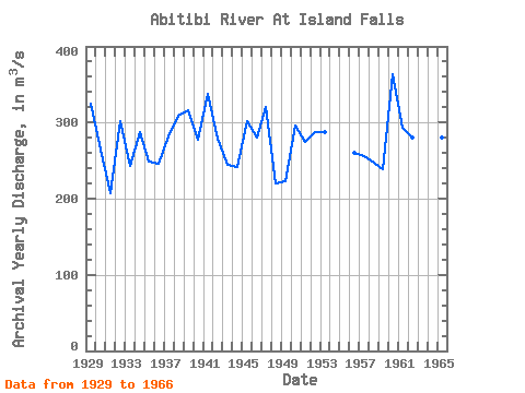
| Year | Jan | Feb | Mar | Apr | May | Jun | Jul | Aug | Sep | Oct | Nov | Dec | Annual | 1924 | 164.00 | 193.00 | 208.00 | 1925 | 413.00 | 652.00 | 458.00 | 333.00 | 183.00 | 1928 | 809.00 | 327.00 | 249.00 | 1929 | 205.00 | 206.00 | 228.00 | 363.00 | 670.00 | 466.00 | 251.00 | 197.00 | 251.00 | 467.00 | 387.00 | 204.00 | 324.58 | 1930 | 192.00 | 198.00 | 185.00 | 302.00 | 628.00 | 526.00 | 300.00 | 139.00 | 141.00 | 194.00 | 208.00 | 162.00 | 264.58 | 1931 | 142.00 | 140.00 | 145.00 | 309.00 | 445.00 | 191.00 | 162.00 | 126.00 | 105.00 | 178.00 | 310.00 | 233.00 | 207.17 | 1932 | 198.00 | 208.00 | 216.00 | 346.00 | 505.00 | 152.00 | 186.00 | 232.00 | 294.00 | 605.00 | 448.00 | 226.00 | 301.33 | 1933 | 211.00 | 206.00 | 217.00 | 557.00 | 629.00 | 287.00 | 167.00 | 169.00 | 136.00 | 133.00 | 115.00 | 95.80 | 243.57 | 1934 | 106.00 | 107.00 | 133.00 | 194.00 | 909.00 | 402.00 | 229.00 | 162.00 | 244.00 | 278.00 | 415.00 | 276.00 | 287.92 | 1935 | 196.00 | 213.00 | 221.00 | 401.00 | 442.00 | 299.00 | 216.00 | 179.00 | 187.00 | 276.00 | 196.00 | 155.00 | 248.42 | 1936 | 112.00 | 114.00 | 140.00 | 248.00 | 950.00 | 463.00 | 180.00 | 128.00 | 133.00 | 183.00 | 161.00 | 141.00 | 246.08 | 1937 | 140.00 | 144.00 | 156.00 | 434.00 | 580.00 | 240.00 | 329.00 | 227.00 | 217.00 | 320.00 | 361.00 | 237.00 | 282.08 | 1938 | 188.00 | 200.00 | 265.00 | 747.00 | 604.00 | 397.00 | 241.00 | 348.00 | 186.00 | 167.00 | 207.00 | 161.00 | 309.25 | 1939 | 183.00 | 236.00 | 262.00 | 337.00 | 957.00 | 312.00 | 445.00 | 163.00 | 210.00 | 290.00 | 213.00 | 188.00 | 316.33 | 1940 | 220.00 | 195.00 | 172.00 | 253.00 | 704.00 | 502.00 | 260.00 | 186.00 | 221.00 | 199.00 | 232.00 | 187.00 | 277.58 | 1941 | 170.00 | 172.00 | 189.00 | 560.00 | 456.00 | 206.00 | 177.00 | 262.00 | 502.00 | 618.00 | 469.00 | 265.00 | 337.17 | 1942 | 215.00 | 221.00 | 232.00 | 587.00 | 440.00 | 219.00 | 191.00 | 177.00 | 242.00 | 357.00 | 289.00 | 174.00 | 278.67 | 1943 | 177.00 | 192.00 | 176.00 | 312.00 | 459.00 | 557.00 | 242.00 | 190.00 | 180.00 | 142.00 | 171.00 | 141.00 | 244.92 | 1944 | 145.00 | 144.00 | 164.00 | 320.00 | 516.00 | 274.00 | 144.00 | 210.00 | 252.00 | 314.00 | 229.00 | 179.00 | 240.92 | 1945 | 187.00 | 174.00 | 336.00 | 453.00 | 494.00 | 565.00 | 334.00 | 187.00 | 207.00 | 218.00 | 287.00 | 171.00 | 301.08 | 1946 | 173.00 | 192.00 | 390.00 | 350.00 | 616.00 | 441.00 | 243.00 | 171.00 | 229.00 | 192.00 | 198.00 | 168.00 | 280.25 | 1947 | 172.00 | 183.00 | 190.00 | 237.00 | 1160.00 | 860.00 | 183.00 | 185.00 | 168.00 | 173.00 | 166.00 | 171.00 | 320.67 | 1948 | 156.00 | 130.00 | 137.00 | 438.00 | 426.00 | 193.00 | 196.00 | 226.00 | 183.00 | 200.00 | 199.00 | 159.00 | 220.25 | 1949 | 153.00 | 159.00 | 162.00 | 389.00 | 355.00 | 382.00 | 200.00 | 181.00 | 178.00 | 175.00 | 184.00 | 161.00 | 223.25 | 1950 | 146.00 | 153.00 | 154.00 | 288.00 | 920.00 | 456.00 | 415.00 | 192.00 | 174.00 | 195.00 | 248.00 | 219.00 | 296.67 | 1951 | 220.00 | 219.00 | 253.00 | 739.00 | 281.00 | 248.00 | 205.00 | 163.00 | 169.00 | 304.00 | 273.00 | 219.00 | 274.42 | 1952 | 217.00 | 236.00 | 228.00 | 485.00 | 505.00 | 372.00 | 267.00 | 250.00 | 202.00 | 223.00 | 255.00 | 209.00 | 287.42 | 1953 | 255.00 | 236.00 | 316.00 | 566.00 | 663.00 | 218.00 | 174.00 | 157.00 | 260.00 | 201.00 | 209.00 | 201.00 | 288.00 | 1954 | 200.00 | 215.00 | 244.00 | 497.00 | 456.00 | 273.00 | 307.00 | 215.00 | 222.00 | 1955 | 200.00 | 205.00 | 174.00 | 1956 | 170.00 | 186.00 | 207.00 | 233.00 | 772.00 | 387.00 | 232.00 | 184.00 | 209.00 | 194.00 | 181.00 | 159.00 | 259.50 | 1957 | 160.00 | 165.00 | 196.00 | 524.00 | 237.00 | 272.00 | 578.00 | 153.00 | 153.00 | 167.00 | 273.00 | 190.00 | 255.67 | 1958 | 218.00 | 226.00 | 233.00 | 326.00 | 243.00 | 231.00 | 218.00 | 174.00 | 232.00 | 366.00 | 295.00 | 213.00 | 247.92 | 1959 | 210.00 | 221.00 | 232.00 | 381.00 | 473.00 | 200.00 | 175.00 | 141.00 | 166.00 | 265.00 | 201.00 | 208.00 | 239.42 | 1960 | 203.00 | 225.00 | 237.00 | 397.00 | 1390.00 | 427.00 | 270.00 | 266.00 | 236.00 | 236.00 | 258.00 | 212.00 | 363.08 | 1961 | 221.00 | 175.00 | 202.00 | 356.00 | 437.00 | 326.00 | 238.00 | 175.00 | 478.00 | 356.00 | 293.00 | 263.00 | 293.33 | 1962 | 274.00 | 282.00 | 266.00 | 350.00 | 639.00 | 348.00 | 171.00 | 201.00 | 289.00 | 199.00 | 187.00 | 154.00 | 280.00 | 1963 | 137.00 | 138.00 | 165.00 | 347.00 | 319.00 | 255.00 | 170.00 | 174.00 | 181.00 | 184.00 | 171.00 | 163.00 | 200.33 | 1964 | 182.00 | 191.00 | 191.00 | 561.00 | 524.00 | 610.00 | 231.00 | 174.00 | 205.00 | 315.00 | 240.00 | 200.00 | 302.00 | 1965 | 184.00 | 209.00 | 220.00 | 235.00 | 666.00 | 217.00 | 213.00 | 200.00 | 296.00 | 465.00 | 239.00 | 224.00 | 280.67 | 1966 | 212.00 | 248.00 | 231.00 | 468.00 | 388.00 | 279.00 | 164.00 | 185.00 | 194.00 | 465.00 | 370.00 | 336.00 | 295.00 | 1967 | 291.00 | 377.00 | 344.00 | 719.00 | 975.00 | 562.00 | 214.00 | 224.00 | 214.00 |
|---|
 Return to R-Arctic Net Home Page