|
|
| Point ID: 4321 | Downloads | Plots | Site Data | Code: 04CB001 |
|
| Download | |
|---|---|
| Site Descriptor Information | Site Time Series Data |
| Link to all available data | |
|
|
|
| View: | Statistics | All |
| Units: | mm |
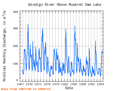
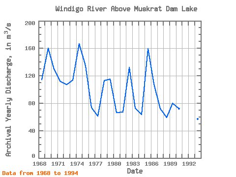
| Year | Jan | Feb | Mar | Apr | May | Jun | Jul | Aug | Sep | Oct | Nov | Dec | Annual | 1967 | 65.00 | 58.30 | 52.00 | 1968 | 45.70 | 40.80 | 40.40 | 45.40 | 82.60 | 178.00 | 180.00 | 172.00 | 182.00 | 160.00 | 139.00 | 106.00 | 114.33 | 1969 | 80.30 | 71.30 | 62.50 | 69.90 | 126.00 | 132.00 | 173.00 | 193.00 | 232.00 | 324.00 | 273.00 | 189.00 | 160.50 | 1970 | 103.00 | 74.40 | 67.20 | 67.80 | 159.00 | 167.00 | 207.00 | 151.00 | 134.00 | 143.00 | 151.00 | 127.00 | 129.28 | 1971 | 89.90 | 66.10 | 57.40 | 86.00 | 226.00 | 173.00 | 134.00 | 116.00 | 83.00 | 89.80 | 119.00 | 100.00 | 111.68 | 1972 | 74.00 | 65.60 | 58.00 | 124.00 | 196.00 | 166.00 | 126.00 | 101.00 | 86.10 | 107.00 | 109.00 | 71.70 | 107.03 | 1973 | 57.20 | 54.00 | 54.00 | 57.10 | 177.00 | 152.00 | 187.00 | 133.00 | 125.00 | 135.00 | 127.00 | 104.00 | 113.53 | 1974 | 83.20 | 67.50 | 54.20 | 54.30 | 128.00 | 253.00 | 225.00 | 284.00 | 298.00 | 247.00 | 172.00 | 132.00 | 166.52 | 1975 | 93.50 | 70.90 | 60.80 | 67.40 | 159.00 | 193.00 | 155.00 | 219.00 | 216.00 | 163.00 | 126.00 | 92.40 | 134.67 | 1976 | 60.00 | 48.20 | 43.60 | 66.30 | 138.00 | 132.00 | 99.30 | 74.70 | 63.40 | 57.30 | 52.80 | 45.30 | 73.41 | 1977 | 32.10 | 27.30 | 26.90 | 42.10 | 85.20 | 77.00 | 69.30 | 67.90 | 85.60 | 89.10 | 75.20 | 61.10 | 61.57 | 1978 | 50.80 | 44.40 | 39.50 | 38.60 | 108.00 | 125.00 | 175.00 | 179.00 | 184.00 | 159.00 | 147.00 | 103.00 | 112.78 | 1979 | 76.70 | 63.40 | 57.40 | 72.20 | 155.00 | 184.00 | 138.00 | 124.00 | 127.00 | 143.00 | 148.00 | 92.20 | 115.08 | 1980 | 55.10 | 44.90 | 46.90 | 67.40 | 124.00 | 86.90 | 59.00 | 50.10 | 55.30 | 77.60 | 73.60 | 55.20 | 66.33 | 1981 | 44.60 | 36.60 | 32.00 | 36.60 | 67.40 | 107.00 | 92.20 | 61.20 | 59.50 | 92.00 | 99.90 | 76.50 | 67.12 | 1982 | 55.20 | 47.20 | 47.40 | 52.80 | 195.00 | 296.00 | 255.00 | 183.00 | 149.00 | 132.00 | 102.00 | 71.70 | 132.19 | 1983 | 58.70 | 50.30 | 44.70 | 46.60 | 105.00 | 129.00 | 141.00 | 84.30 | 58.80 | 53.50 | 56.00 | 41.90 | 72.48 | 1984 | 33.90 | 29.90 | 28.10 | 43.20 | 110.00 | 110.00 | 97.60 | 75.80 | 55.10 | 56.70 | 62.10 | 58.50 | 63.41 | 1985 | 48.70 | 43.60 | 41.40 | 49.50 | 194.00 | 221.00 | 313.00 | 241.00 | 231.00 | 239.00 | 181.00 | 113.00 | 159.68 | 1986 | 79.10 | 61.10 | 49.70 | 69.10 | 215.00 | 154.00 | 118.00 | 123.00 | 111.00 | 132.00 | 109.00 | 71.20 | 107.68 | 1987 | 57.40 | 52.70 | 51.10 | 85.40 | 128.00 | 112.00 | 82.90 | 63.00 | 56.20 | 62.50 | 65.00 | 51.90 | 72.34 | 1988 | 42.40 | 36.70 | 34.10 | 38.00 | 84.50 | 91.70 | 70.40 | 55.30 | 57.20 | 71.60 | 69.50 | 58.80 | 59.18 | 1989 | 47.80 | 40.20 | 34.20 | 31.70 | 100.00 | 139.00 | 111.00 | 96.40 | 114.00 | 106.00 | 82.90 | 59.60 | 80.23 | 1990 | 36.20 | 28.10 | 30.80 | 47.90 | 185.00 | 157.00 | 107.00 | 68.60 | 54.00 | 54.50 | 49.70 | 42.90 | 71.81 | 1991 | 36.00 | 30.40 | 26.10 | 31.60 | 81.50 | 84.80 | 66.50 | 51.60 | 40.80 | 62.90 | 66.70 | 53.30 | 52.68 | 1992 | 42.80 | 36.80 | 34.10 | 32.90 | 167.00 | 228.00 | 182.00 | 168.00 | 163.00 | 145.00 | 98.00 | 69.80 | 113.95 | 1993 | 57.40 | 50.20 | 45.30 | 43.80 | 42.60 | 39.60 | 52.00 | 74.30 | 68.90 | 71.70 | 74.30 | 59.50 | 56.63 | 1994 | 40.20 | 31.40 | 29.90 | 33.40 | 74.20 | 83.50 | 118.00 | 168.00 | 125.00 | 116.00 | 166.00 | 129.00 | 92.88 |
|---|
 Return to R-Arctic Net Home Page