|
|
| Point ID: 3665 | Downloads | Plots | Site Data | Code: 10MC005 |
|
| Download | |
|---|---|
| Site Descriptor Information | Site Time Series Data |
| Link to all available data | |
|
|
|
| View: | Statistics | All |
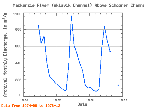
| Units: | mm |
| Year | Jan | Feb | Mar | Apr | May | Jun | Jul | Aug | Sep | Oct | Nov | Dec | Annual | 1974 | 932.00 | 696.00 | 794.00 | 447.00 | 268.00 | 230.00 | 184.00 | 1975 | 147.00 | 116.00 | 89.00 | 73.20 | 404.00 | 1060.00 | 669.00 | 557.00 | 434.00 | 345.00 | 146.00 | 111.00 | 345.93 | 1976 | 117.00 | 76.50 | 68.40 | 94.20 | 625.00 | 919.00 | 740.00 | 589.00 | 483.00 | 266.00 | 149.00 | 105.00 | 352.68 |
|---|
 Return to R-Arctic Net Home Page