|
|
| Point ID: 3664 | Downloads | Plots | Site Data | Code: 10MC004 |
|
| Download | |
|---|---|
| Site Descriptor Information | Site Time Series Data |
| Link to all available data | |
|
|
|
| View: | Statistics | All |
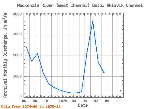
| Units: | mm |
| Year | Jan | Feb | Mar | Apr | May | Jun | Jul | Aug | Sep | Oct | Nov | Dec | Annual | 1974 | 2380.00 | 1720.00 | 2070.00 | 1150.00 | 637.00 | 463.00 | 358.00 | 1975 | 268.00 | 209.00 | 213.00 | 268.00 | 2130.00 | 3620.00 | 1670.00 | 1170.00 | 960.00 | 711.00 | 303.00 | 234.00 | 979.67 |
|---|
 Return to R-Arctic Net Home Page