|
|
| Point ID: 3662 | Downloads | Plots | Site Data | Code: 10MC002 |
|
| Download | |
|---|---|
| Site Descriptor Information | Site Time Series Data |
| Link to all available data | |
|
|
|
| View: | Statistics | All |
| Units: | mm |
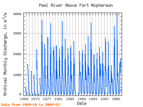
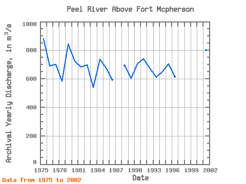
| Year | Jan | Feb | Mar | Apr | May | Jun | Jul | Aug | Sep | Oct | Nov | Dec | Annual | 1969 | 405.00 | 200.00 | 135.00 | 1970 | 111.00 | 100.00 | 89.70 | 79.10 | 1490.00 | 1080.00 | 901.00 | 369.00 | 177.00 | 113.00 | 1971 | 91.60 | 77.60 | 69.50 | 1150.00 | 367.00 | 193.00 | 108.00 | 1972 | 80.90 | 70.30 | 59.80 | 55.00 | 862.00 | 834.00 | 994.00 | 315.00 | 119.00 | 86.00 | 1973 | 77.10 | 65.00 | 52.20 | 48.30 | 1310.00 | 2220.00 | 1140.00 | 390.00 | 98.20 | 76.10 | 1974 | 64.90 | 58.30 | 54.30 | 55.70 | 824.00 | 232.00 | 125.00 | 109.00 | 1975 | 94.30 | 85.00 | 77.30 | 74.90 | 2190.00 | 3650.00 | 1520.00 | 1090.00 | 1110.00 | 438.00 | 144.00 | 94.90 | 880.70 | 1976 | 80.80 | 77.10 | 74.20 | 101.00 | 2470.00 | 2010.00 | 861.00 | 1300.00 | 615.00 | 389.00 | 186.00 | 99.00 | 688.59 | 1977 | 77.10 | 73.60 | 73.60 | 80.50 | 2820.00 | 2710.00 | 1080.00 | 505.00 | 426.00 | 349.00 | 137.00 | 90.90 | 701.89 | 1978 | 72.50 | 60.20 | 54.00 | 63.70 | 405.00 | 3470.00 | 1200.00 | 572.00 | 578.00 | 315.00 | 97.00 | 83.60 | 580.92 | 1979 | 80.90 | 77.10 | 72.30 | 70.80 | 2170.00 | 1900.00 | 2360.00 | 1400.00 | 1130.00 | 612.00 | 187.00 | 80.80 | 845.08 | 1980 | 65.70 | 59.90 | 61.30 | 66.80 | 2420.00 | 2310.00 | 805.00 | 1650.00 | 675.00 | 276.00 | 159.00 | 100.00 | 720.73 | 1981 | 76.50 | 66.10 | 62.20 | 59.50 | 1680.00 | 1490.00 | 2240.00 | 1160.00 | 627.00 | 385.00 | 203.00 | 123.00 | 681.02 | 1982 | 83.30 | 65.70 | 59.40 | 59.50 | 1150.00 | 3580.00 | 1150.00 | 1040.00 | 655.00 | 311.00 | 129.00 | 104.00 | 698.91 | 1983 | 97.90 | 74.40 | 68.60 | 82.10 | 735.00 | 2730.00 | 827.00 | 878.00 | 562.00 | 249.00 | 120.00 | 68.30 | 541.02 | 1984 | 51.40 | 48.20 | 47.00 | 64.80 | 2150.00 | 2270.00 | 1650.00 | 1180.00 | 860.00 | 286.00 | 126.00 | 103.00 | 736.37 | 1985 | 83.40 | 80.00 | 77.40 | 67.60 | 2170.00 | 2380.00 | 936.00 | 676.00 | 966.00 | 459.00 | 131.00 | 93.80 | 676.68 | 1986 | 77.10 | 73.80 | 71.90 | 71.70 | 372.00 | 2610.00 | 961.00 | 1530.00 | 748.00 | 300.00 | 175.00 | 110.00 | 591.71 | 1988 | 88.20 | 74.30 | 70.10 | 88.50 | 1900.00 | 2150.00 | 1180.00 | 1010.00 | 1130.00 | 336.00 | 158.00 | 140.00 | 693.76 | 1989 | 128.00 | 119.00 | 111.00 | 113.00 | 1820.00 | 2190.00 | 800.00 | 712.00 | 642.00 | 337.00 | 163.00 | 124.00 | 604.92 | 1990 | 113.00 | 105.00 | 98.90 | 100.00 | 1500.00 | 2460.00 | 753.00 | 1180.00 | 1170.00 | 598.00 | 243.00 | 140.00 | 705.08 | 1991 | 128.00 | 121.00 | 111.00 | 114.00 | 2840.00 | 1780.00 | 990.00 | 1330.00 | 835.00 | 386.00 | 130.00 | 119.00 | 740.33 | 1992 | 116.00 | 107.00 | 98.00 | 92.30 | 1620.00 | 3500.00 | 963.00 | 663.00 | 496.00 | 226.00 | 127.00 | 96.20 | 675.38 | 1993 | 78.30 | 74.10 | 81.70 | 95.00 | 1890.00 | 1990.00 | 926.00 | 642.00 | 926.00 | 366.00 | 137.00 | 124.00 | 610.84 | 1994 | 105.00 | 83.20 | 66.70 | 68.30 | 1490.00 | 2040.00 | 1640.00 | 917.00 | 765.00 | 347.00 | 137.00 | 126.00 | 648.77 | 1995 | 99.50 | 85.90 | 78.90 | 97.70 | 2310.00 | 1500.00 | 1040.00 | 926.00 | 1520.00 | 490.00 | 192.00 | 126.00 | 705.50 | 1996 | 93.00 | 83.00 | 81.40 | 82.70 | 996.00 | 2100.00 | 944.00 | 1180.00 | 1160.00 | 373.00 | 175.00 | 128.00 | 616.34 | 1997 | 95.70 | 80.60 | 72.40 | 71.40 | 2780.00 | 2440.00 | 1220.00 | 1250.00 | 950.00 | 445.00 | 1998 | 87.10 | 180.00 | 2590.00 | 2030.00 | 913.00 | 669.00 | 688.00 | 378.00 | 116.00 | 111.00 | 1999 | 102.00 | 83.60 | 75.80 | 78.10 | 915.00 | 1450.00 | 640.00 | 834.00 | 719.00 | 419.00 | 212.00 | 123.00 | 470.96 | 2000 | 98.80 | 88.10 | 81.60 | 79.10 | 1410.00 | 3350.00 | 2180.00 | 1740.00 | 1090.00 | 509.00 | 242.00 | 147.00 | 917.97 | 2001 | 139.00 | 114.00 | 98.60 | 99.00 | 1030.00 | 4000.00 | 1380.00 | 944.00 | 1070.00 | 424.00 | 201.00 | 115.00 | 801.22 | 2002 | 103.00 | 88.70 | 87.90 | 92.60 | 1480.00 | 1620.00 | 1080.00 | 1740.00 | 1010.00 | 468.00 | 274.00 | 220.00 | 688.68 |
|---|
 Return to R-Arctic Net Home Page