
|
|
| Point ID: 3635 | Downloads | Plots | Site Data | Code: 10JA002 |
|
| Download | |
|---|---|
| Site Descriptor Information | Site Time Series Data |
| Link to all available data | |
|
|
|
| View: | Statistics | All |
| Units: | mm |
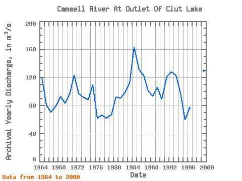
| Year | Jan | Feb | Mar | Apr | May | Jun | Jul | Aug | Sep | Oct | Nov | Dec | Annual | 1933 | 42.60 | 1934 | 47.20 | 32.20 | 31.50 | 45.50 | 65.90 | 118.00 | 131.00 | 147.00 | 134.00 | 124.00 | 106.00 | 1963 | 115.00 | 112.00 | 1964 | 106.00 | 99.20 | 91.10 | 82.60 | 84.00 | 134.00 | 159.00 | 163.00 | 148.00 | 133.00 | 121.00 | 112.00 | 119.41 | 1965 | 96.80 | 82.40 | 72.50 | 64.20 | 62.20 | 85.60 | 101.00 | 93.10 | 82.50 | 75.60 | 75.90 | 77.40 | 80.77 | 1966 | 72.30 | 65.60 | 58.30 | 48.90 | 48.10 | 85.00 | 94.30 | 89.00 | 83.00 | 72.80 | 66.80 | 62.30 | 70.53 | 1967 | 61.80 | 58.40 | 53.50 | 49.40 | 47.20 | 66.30 | 88.00 | 101.00 | 105.00 | 107.00 | 107.00 | 107.00 | 79.30 | 1968 | 106.00 | 99.20 | 91.70 | 85.70 | 77.00 | 96.50 | 114.00 | 104.00 | 94.50 | 87.60 | 82.30 | 76.20 | 92.89 | 1969 | 69.90 | 66.70 | 64.10 | 58.20 | 65.10 | 75.60 | 82.50 | 95.30 | 105.00 | 106.00 | 107.00 | 107.00 | 83.53 | 1970 | 101.00 | 95.90 | 88.80 | 79.50 | 74.50 | 87.50 | 97.90 | 96.60 | 101.00 | 107.00 | 112.00 | 110.00 | 95.97 | 1971 | 108.00 | 100.00 | 94.50 | 87.60 | 102.00 | 161.00 | 179.00 | 163.00 | 142.00 | 125.00 | 113.00 | 103.00 | 123.17 | 1972 | 93.90 | 85.00 | 75.70 | 67.90 | 64.90 | 101.00 | 130.00 | 128.00 | 118.00 | 107.00 | 101.00 | 94.40 | 97.23 | 1973 | 87.50 | 81.40 | 76.00 | 71.00 | 84.50 | 110.00 | 111.00 | 108.00 | 104.00 | 94.10 | 85.60 | 81.60 | 91.22 | 1974 | 76.80 | 71.50 | 67.20 | 63.10 | 70.80 | 88.40 | 102.00 | 105.00 | 105.00 | 103.00 | 106.00 | 104.00 | 88.57 | 1975 | 99.50 | 90.70 | 79.40 | 69.30 | 99.80 | 153.00 | 163.00 | 141.00 | 124.00 | 108.00 | 97.40 | 88.30 | 109.45 | 1976 | 78.90 | 70.70 | 62.60 | 61.00 | 63.80 | 72.20 | 72.80 | 62.50 | 56.10 | 52.30 | 48.60 | 46.80 | 62.36 | 1977 | 44.90 | 42.90 | 41.10 | 39.50 | 51.00 | 84.10 | 93.00 | 87.40 | 84.50 | 78.10 | 74.70 | 71.20 | 66.03 | 1978 | 65.80 | 60.10 | 56.10 | 52.50 | 53.20 | 66.10 | 71.60 | 71.40 | 66.30 | 61.30 | 60.20 | 57.50 | 61.84 | 1979 | 55.30 | 52.20 | 48.90 | 46.40 | 50.50 | 78.80 | 89.60 | 85.80 | 79.20 | 73.90 | 71.10 | 69.60 | 66.78 | 1980 | 67.00 | 61.40 | 54.30 | 49.70 | 77.00 | 123.00 | 133.00 | 124.00 | 112.00 | 107.00 | 101.00 | 97.60 | 92.25 | 1981 | 93.40 | 84.00 | 74.70 | 66.40 | 67.20 | 87.50 | 104.00 | 103.00 | 95.60 | 99.40 | 105.00 | 104.00 | 90.35 | 1982 | 97.10 | 90.10 | 82.20 | 73.60 | 72.70 | 109.00 | 124.00 | 119.00 | 112.00 | 104.00 | 101.00 | 96.00 | 98.39 | 1983 | 88.70 | 82.10 | 75.70 | 68.60 | 61.40 | 91.10 | 124.00 | 136.00 | 149.00 | 155.00 | 156.00 | 147.00 | 111.22 | 1984 | 134.00 | 123.00 | 110.00 | 99.90 | 117.00 | 155.00 | 187.00 | 208.00 | 222.00 | 217.00 | 204.00 | 182.00 | 163.24 | 1985 | 156.00 | 134.00 | 119.00 | 105.00 | 112.00 | 141.00 | 147.00 | 146.00 | 146.00 | 135.00 | 122.00 | 109.00 | 131.00 | 1986 | 99.40 | 92.80 | 86.70 | 80.80 | 83.70 | 143.00 | 172.00 | 168.00 | 159.00 | 144.00 | 129.00 | 115.00 | 122.78 | 1987 | 103.00 | 93.60 | 85.90 | 79.00 | 78.10 | 105.00 | 129.00 | 121.00 | 114.00 | 106.00 | 99.90 | 95.90 | 100.87 | 1988 | 89.30 | 83.20 | 77.10 | 70.70 | 65.70 | 82.30 | 102.00 | 105.00 | 109.00 | 114.00 | 114.00 | 111.00 | 93.61 | 1989 | 104.00 | 97.60 | 88.00 | 80.30 | 82.40 | 113.00 | 132.00 | 129.00 | 118.00 | 113.00 | 109.00 | 105.00 | 105.94 | 1990 | 97.80 | 89.40 | 81.60 | 74.50 | 70.60 | 91.40 | 103.00 | 99.10 | 96.00 | 92.20 | 90.70 | 87.80 | 89.51 | 1991 | 82.40 | 77.00 | 70.60 | 64.80 | 87.00 | 137.00 | 171.00 | 175.00 | 166.00 | 153.00 | 141.00 | 130.00 | 121.23 | 1992 | 117.00 | 105.00 | 95.40 | 87.60 | 88.10 | 149.00 | 181.00 | 176.00 | 156.00 | 137.00 | 127.00 | 116.00 | 127.92 | 1993 | 102.00 | 91.80 | 81.90 | 73.60 | 78.30 | 120.00 | 151.00 | 166.00 | 167.00 | 157.00 | 147.00 | 137.00 | 122.72 | 1994 | 125.00 | 111.00 | 100.00 | 89.80 | 91.30 | 113.00 | 119.00 | 106.00 | 92.40 | 82.20 | 75.60 | 70.70 | 98.00 | 1995 | 66.40 | 61.80 | 57.70 | 53.00 | 57.10 | 66.50 | 69.20 | 64.40 | 59.00 | 57.30 | 55.80 | 54.00 | 60.18 | 1996 | 52.50 | 49.70 | 47.20 | 44.20 | 45.20 | 80.10 | 99.20 | 102.00 | 104.00 | 104.00 | 99.10 | 93.20 | 76.70 | 1997 | 86.50 | 92.00 | 130.00 | 155.00 | 156.00 | 149.00 | 139.00 | 132.00 | 124.00 | 1998 | 115.00 | 106.00 | 96.10 | 87.80 | 95.90 | 108.00 | 110.00 | 102.00 | 100.00 | 101.00 | 104.00 | 103.00 | 102.40 | 1999 | 100.00 | 94.60 | 89.10 | 83.90 | 91.30 | 137.00 | 160.00 | 165.00 | 164.00 | 159.00 | 155.00 | 150.00 | 129.07 | 2000 | 140.00 | 128.00 | 117.00 | 106.00 | 115.00 | 134.00 | 133.00 | 122.00 | 110.00 | 108.00 | 104.00 | 99.60 | 118.05 |
|---|
 Return to R-Arctic Net Home Page