|
|
| Point ID: 3128 | Downloads | Plots | Site Data | Code: 06FB001 |
|
| Download | |
|---|---|
| Site Descriptor Information | Site Time Series Data |
| Link to all available data | |
|
|
|
| View: | Statistics | All |
| Units: | mm |
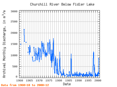
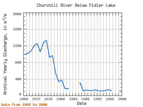
| Year | Jan | Feb | Mar | Apr | May | Jun | Jul | Aug | Sep | Oct | Nov | Dec | Annual | 1960 | 1490.00 | 1962 | 2140.00 | 1620.00 | 1963 | 1580.00 | 1964 | 1130.00 | 1340.00 | 1320.00 | 1290.00 | 1965 | 1200.00 | 1110.00 | 1020.00 | 1100.00 | 1250.00 | 1440.00 | 1410.00 | 1300.00 | 1150.00 | 1966 | 924.00 | 828.00 | 794.00 | 1967 | 766.00 | 740.00 | 1350.00 | 1230.00 | 1090.00 | 981.00 | 1968 | 746.00 | 767.00 | 781.00 | 800.00 | 929.00 | 1310.00 | 1290.00 | 1100.00 | 1010.00 | 1080.00 | 1070.00 | 935.00 | 984.83 | 1969 | 798.00 | 777.00 | 793.00 | 851.00 | 973.00 | 1100.00 | 1110.00 | 967.00 | 1130.00 | 1350.00 | 1270.00 | 1100.00 | 1018.25 | 1970 | 893.00 | 815.00 | 756.00 | 699.00 | 924.00 | 1320.00 | 1310.00 | 1290.00 | 1270.00 | 1220.00 | 1230.00 | 1100.00 | 1068.92 | 1971 | 942.00 | 893.00 | 861.00 | 797.00 | 1070.00 | 1100.00 | 1620.00 | 1410.00 | 1390.00 | 1530.00 | 1540.00 | 1380.00 | 1211.08 | 1972 | 1250.00 | 1170.00 | 1130.00 | 1050.00 | 1240.00 | 1470.00 | 1540.00 | 1430.00 | 1290.00 | 1180.00 | 1100.00 | 1120.00 | 1247.50 | 1973 | 1100.00 | 1030.00 | 992.00 | 956.00 | 1120.00 | 1240.00 | 1220.00 | 990.00 | 918.00 | 951.00 | 1040.00 | 1090.00 | 1053.92 | 1974 | 1110.00 | 1070.00 | 1020.00 | 977.00 | 1020.00 | 1270.00 | 1430.00 | 1560.00 | 1550.00 | 1520.00 | 1450.00 | 1370.00 | 1278.92 | 1975 | 1290.00 | 1190.00 | 1100.00 | 1050.00 | 1190.00 | 1440.00 | 1690.00 | 1660.00 | 1540.00 | 1450.00 | 1320.00 | 1080.00 | 1333.33 | 1976 | 979.00 | 804.00 | 761.00 | 1100.00 | 1240.00 | 884.00 | 473.00 | 525.00 | 775.00 | 1110.00 | 1240.00 | 1160.00 | 920.92 | 1977 | 995.00 | 867.00 | 733.00 | 756.00 | 1370.00 | 1750.00 | 1550.00 | 1160.00 | 919.00 | 748.00 | 480.00 | 258.00 | 965.50 | 1978 | 199.00 | 199.00 | 199.00 | 203.00 | 408.00 | 956.00 | 532.00 | 759.00 | 892.00 | 713.00 | 711.00 | 609.00 | 531.67 | 1979 | 535.00 | 377.00 | 220.00 | 169.00 | 281.00 | 461.00 | 848.00 | 497.00 | 158.00 | 168.00 | 177.00 | 147.00 | 336.50 | 1980 | 129.00 | 128.00 | 127.00 | 171.00 | 225.00 | 348.00 | 463.00 | 460.00 | 1150.00 | 610.00 | 386.00 | 290.00 | 373.92 | 1981 | 241.00 | 207.00 | 204.00 | 198.00 | 271.00 | 185.00 | 99.30 | 76.10 | 64.60 | 184.00 | 183.00 | 128.00 | 170.08 | 1982 | 120.00 | 109.00 | 113.00 | 113.00 | 181.00 | 248.00 | 375.00 | 117.00 | 138.00 | 200.00 | 172.00 | 135.00 | 168.42 | 1983 | 117.00 | 88.40 | 68.60 | 66.20 | 93.90 | 1984 | 161.00 | 151.00 | 137.00 | 61.70 | 58.60 | 130.00 | 155.00 | 124.00 | 1985 | 113.00 | 98.40 | 77.80 | 245.00 | 287.00 | 63.00 | 143.00 | 139.00 | 114.00 | 1986 | 101.00 | 68.40 | 55.80 | 47.90 | 274.00 | 649.00 | 1060.00 | 617.00 | 282.00 | 145.00 | 138.00 | 115.00 | 296.09 | 1987 | 98.70 | 79.00 | 76.30 | 93.60 | 173.00 | 138.00 | 103.00 | 76.40 | 87.40 | 105.00 | 162.00 | 130.00 | 110.20 | 1988 | 110.00 | 104.00 | 78.80 | 65.70 | 201.00 | 242.00 | 137.00 | 127.00 | 96.50 | 90.20 | 183.00 | 142.00 | 131.43 | 1989 | 128.00 | 98.80 | 63.80 | 53.80 | 224.00 | 260.00 | 152.00 | 77.50 | 79.90 | 80.50 | 166.00 | 114.00 | 124.86 | 1990 | 87.80 | 76.60 | 62.70 | 54.30 | 84.60 | 200.00 | 147.00 | 96.50 | 73.20 | 89.80 | 245.00 | 179.00 | 116.38 | 1991 | 148.00 | 118.00 | 96.50 | 61.90 | 151.00 | 202.00 | 171.00 | 169.00 | 137.00 | 131.00 | 144.00 | 136.00 | 138.78 | 1992 | 124.00 | 96.10 | 59.80 | 54.90 | 165.00 | 141.00 | 77.30 | 45.10 | 71.20 | 191.00 | 193.00 | 148.00 | 113.87 | 1993 | 135.00 | 117.00 | 87.20 | 70.20 | 137.00 | 92.20 | 94.30 | 72.80 | 61.50 | 135.00 | 165.00 | 136.00 | 108.60 | 1994 | 119.00 | 106.00 | 78.60 | 66.20 | 217.00 | 237.00 | 121.00 | 61.30 | 37.60 | 60.50 | 160.00 | 147.00 | 117.60 | 1995 | 134.00 | 115.00 | 91.30 | 66.30 | 122.00 | 125.00 | 69.20 | 179.00 | 269.00 | 147.00 | 203.00 | 182.00 | 141.90 | 1996 | 125.00 | 94.60 | 68.60 | 70.60 | 115.00 | 155.00 | 242.00 | 150.00 | 64.40 | 72.50 | 168.00 | 144.00 | 122.47 | 1997 | 130.00 | 103.00 | 85.80 | 58.90 | 72.70 | 129.00 | 80.80 | 339.00 | 696.00 | 1040.00 | 1060.00 | 1160.00 | 412.93 | 1998 | 1090.00 | 682.00 | 427.00 | 245.00 | 577.00 | 328.00 | 92.80 | 84.70 | 52.00 | 55.50 | 150.00 | 212.00 | 333.00 | 1999 | 117.00 | 75.90 | 63.20 | 76.20 | 129.00 | 133.00 | 76.60 | 98.30 | 108.00 | 93.30 | 169.00 | 219.00 | 113.21 | 2000 | 112.00 | 70.40 | 56.60 | 83.20 | 258.00 | 222.00 | 174.00 | 851.00 | 359.00 | 157.00 | 179.00 | 146.00 | 222.35 |
|---|
 Return to R-Arctic Net Home Page