|

|
| Point ID: 3124 | Downloads | Plots | Site Data | Code: 06EB005 |
|
| Download | |
|---|---|
| Site Descriptor Information | Site Time Series Data |
| Link to all available data | |
|
|
|
| View: | Statistics | All |
| Units: | mm |
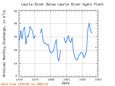
| Year | Jan | Feb | Mar | Apr | May | Jun | Jul | Aug | Sep | Oct | Nov | Dec | Annual | 1978 | 27.70 | 34.80 | 28.30 | 35.00 | 37.10 | 24.10 | 30.60 | 30.40 | 37.70 | 36.10 | 34.00 | 28.80 | 32.05 | 1979 | 30.60 | 33.20 | 36.10 | 27.20 | 25.10 | 25.00 | 23.70 | 24.20 | 19.40 | 1980 | 17.60 | 18.70 | 19.70 | 24.30 | 28.10 | 13.90 | 11.80 | 19.50 | 28.90 | 25.40 | 1981 | 27.30 | 31.00 | 27.40 | 25.50 | 29.40 | 19.40 | 14.80 | 12.80 | 12.60 | 15.80 | 17.10 | 18.60 | 20.98 | 1982 | 17.70 | 14.30 | 16.90 | 19.60 | 35.80 | 40.30 | 34.70 | 33.30 | 24.60 | 16.70 | 21.90 | 21.40 | 24.77 |
|---|
 Return to R-Arctic Net Home Page