|
|
| Point ID: 3067 | Downloads | Plots | Site Data | Code: 05PF064 |
|
| Download | |
|---|---|
| Site Descriptor Information | Site Time Series Data |
| Link to all available data | |
|
|
|
| View: | Statistics | All |
| Units: | mm |
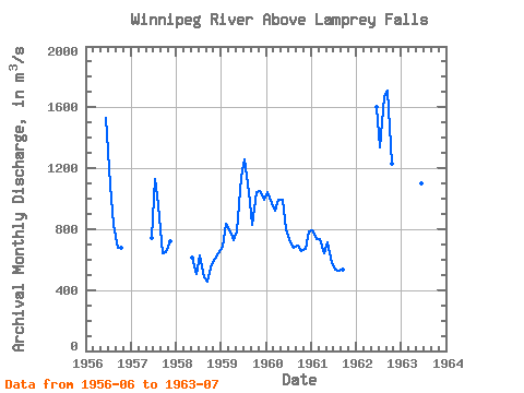
| Year | Jan | Feb | Mar | Apr | May | Jun | Jul | Aug | Sep | Oct | Nov | Dec | Annual | 1956 | 1530.00 | 1090.00 | 829.00 | 678.00 | 675.00 | 1957 | 743.00 | 1130.00 | 954.00 | 642.00 | 652.00 | 724.00 | 1958 | 615.00 | 504.00 | 628.00 | 487.00 | 457.00 | 569.00 | 604.00 | 644.00 | 1959 | 684.00 | 833.00 | 785.00 | 727.00 | 787.00 | 1140.00 | 1260.00 | 1040.00 | 829.00 | 1040.00 | 1050.00 | 996.00 | 930.92 | 1960 | 1040.00 | 972.00 | 919.00 | 995.00 | 996.00 | 802.00 | 711.00 | 676.00 | 693.00 | 659.00 | 668.00 | 785.00 | 826.33 | 1961 | 792.00 | 738.00 | 733.00 | 640.00 | 715.00 | 579.00 | 536.00 | 529.00 | 537.00 | 1962 | 1600.00 | 1340.00 | 1670.00 | 1710.00 | 1230.00 | 1963 | 1100.00 | 1190.00 |
|---|
 Return to R-Arctic Net Home Page