|
|
| Point ID: 3034 | Downloads | Plots | Site Data | Code: 05OF022 |
|
| Download | |
|---|---|
| Site Descriptor Information | Site Time Series Data |
| Link to all available data | |
|
|
|
| View: | Statistics | All |
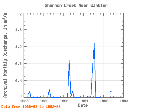
| Units: | mm |
| Year | Jan | Feb | Mar | Apr | May | Jun | Jul | Aug | Sep | Oct | Nov | Dec | Annual | 1988 | 0.06 | 0.13 | 0.00 | 0.00 | 0.00 | 0.00 | 0.00 | 0.00 | 1989 | 0.00 | 0.18 | 0.00 | 0.00 | 0.00 | 0.00 | 0.00 | 0.00 | 1990 | 0.01 | 0.87 | 0.02 | 0.15 | 0.01 | 0.00 | 0.00 | 0.00 | 1991 | 0.01 | 0.01 | 0.01 | 0.65 | 1.29 | 0.00 | 0.00 | 0.00 | 1992 | 1.19 | 0.81 | 0.14 | 0.11 |
|---|
 Return to R-Arctic Net Home Page