|

|
| Point ID: 2783 | Downloads | Plots | Site Data | Code: 04AA001 |
|
| Download | |
|---|---|
| Site Descriptor Information | Site Time Series Data |
| Link to all available data | |
|
|
|
| View: | Statistics | All |
| Units: | mm |
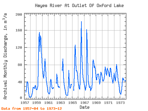
| Year | Jan | Feb | Mar | Apr | May | Jun | Jul | Aug | Sep | Oct | Nov | Dec | Annual | 1957 | 15.80 | 24.30 | 37.00 | 40.50 | 34.70 | 18.10 | 9.52 | 4.94 | 4.41 | 1958 | 4.58 | 4.64 | 5.96 | 8.89 | 14.60 | 26.20 | 27.60 | 26.30 | 25.00 | 30.10 | 32.10 | 26.50 | 19.37 | 1959 | 21.60 | 22.20 | 24.50 | 30.50 | 74.20 | 141.00 | 155.00 | 111.00 | 147.00 | 141.00 | 110.00 | 91.70 | 89.14 | 1960 | 75.10 | 60.60 | 49.80 | 48.70 | 72.20 | 93.80 | 80.70 | 58.40 | 43.70 | 35.10 | 25.50 | 17.90 | 55.12 | 1961 | 14.20 | 12.30 | 11.70 | 17.00 | 40.70 | 46.10 | 38.10 | 27.50 | 23.70 | 25.00 | 26.30 | 1962 | 37.80 | 58.40 | 48.60 | 29.50 | 28.60 | 29.70 | 27.90 | 1963 | 67.60 | 93.50 | 69.20 | 41.20 | 29.00 | 25.60 | 18.30 | 12.10 | 1964 | 9.90 | 9.16 | 9.06 | 9.22 | 36.40 | 67.20 | 40.50 | 26.30 | 25.40 | 30.10 | 34.40 | 1965 | 21.40 | 55.70 | 119.00 | 126.00 | 88.20 | 65.60 | 66.40 | 59.60 | 48.20 | 1966 | 36.70 | 28.80 | 24.30 | 23.40 | 41.90 | 115.00 | 180.00 | 109.00 | 78.50 | 59.50 | 46.10 | 39.80 | 65.25 | 1967 | 35.40 | 29.30 | 20.30 | 23.90 | 34.30 | 162.00 | 130.00 | 68.50 | 43.00 | 34.90 | 27.00 | 27.60 | 53.02 | 1968 | 29.10 | 19.50 | 24.30 | 26.10 | 38.30 | 85.10 | 91.10 | 86.50 | 73.10 | 76.90 | 70.60 | 54.80 | 56.28 | 1969 | 45.50 | 44.90 | 57.30 | 57.70 | 58.70 | 56.30 | 43.30 | 34.60 | 40.80 | 62.90 | 61.00 | 56.10 | 51.59 | 1970 | 48.90 | 42.40 | 41.90 | 42.30 | 48.50 | 62.30 | 74.70 | 67.80 | 56.10 | 55.40 | 71.90 | 68.40 | 56.72 | 1971 | 65.40 | 61.40 | 54.20 | 52.20 | 71.00 | 72.10 | 61.60 | 53.70 | 45.70 | 36.90 | 40.20 | 49.70 | 55.34 | 1972 | 60.40 | 51.80 | 41.90 | 43.70 | 71.20 | 80.50 | 66.20 | 54.40 | 43.30 | 36.80 | 25.20 | 16.10 | 49.29 | 1973 | 13.80 | 10.80 | 15.80 | 23.60 | 35.70 | 48.90 | 48.90 | 44.80 | 39.70 | 41.70 | 42.90 | 37.30 | 33.66 |
|---|
 Return to R-Arctic Net Home Page