|
|
| Point ID: 230 | Downloads | Plots | Site Data | Code: 05BA008 |
|
| Download | |
|---|---|
| Site Descriptor Information | Site Time Series Data |
| Link to all available data | |
|
|
|
| View: | Statistics | All |
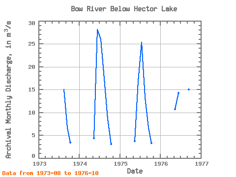
| Units: | mm |
| Year | Jan | Feb | Mar | Apr | May | Jun | Jul | Aug | Sep | Oct | Nov | Dec | Annual | 1973 | 15.00 | 6.58 | 3.37 | 1974 | 4.31 | 28.10 | 26.00 | 17.40 | 8.53 | 3.09 | 1975 | 3.68 | 16.80 | 25.30 | 13.30 | 6.58 | 3.31 | 1976 | 10.70 | 14.20 | 28.00 | 22.00 | 15.00 | 4.33 |
|---|
 Return to R-Arctic Net Home Page