|
|
| Point ID: 222 | Downloads | Plots | Site Data | Code: 05AK001 |
|
| Download | |
|---|---|
| Site Descriptor Information | Site Time Series Data |
| Link to all available data | |
|
|
|
| View: | Statistics | All |
| Units: | mm |
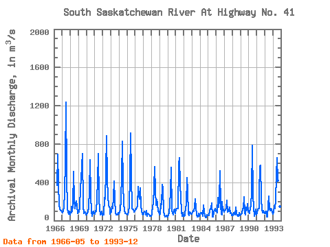
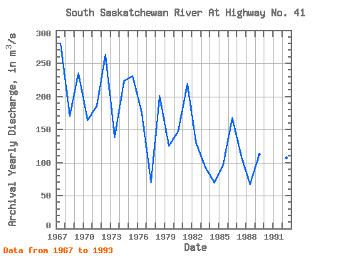
| Year | Jan | Feb | Mar | Apr | May | Jun | Jul | Aug | Sep | Oct | Nov | Dec | Annual | 1966 | 368.00 | 690.00 | 386.00 | 151.00 | 128.00 | 103.00 | 104.00 | 92.60 | 1967 | 80.50 | 94.20 | 143.00 | 287.00 | 628.00 | 1240.00 | 459.00 | 127.00 | 82.40 | 69.80 | 93.90 | 62.20 | 280.58 | 1968 | 90.10 | 85.00 | 147.00 | 94.70 | 158.00 | 515.00 | 218.00 | 128.00 | 176.00 | 204.00 | 151.00 | 75.70 | 170.21 | 1969 | 93.60 | 87.40 | 141.00 | 338.00 | 428.00 | 570.00 | 702.00 | 150.00 | 78.80 | 85.80 | 86.70 | 61.30 | 235.22 | 1970 | 62.80 | 74.30 | 92.50 | 138.00 | 313.00 | 632.00 | 261.00 | 96.70 | 48.30 | 80.20 | 98.40 | 74.00 | 164.27 | 1971 | 69.50 | 107.00 | 94.40 | 223.00 | 414.00 | 696.00 | 220.00 | 123.00 | 57.70 | 67.50 | 98.10 | 50.70 | 185.07 | 1972 | 57.40 | 58.70 | 242.00 | 226.00 | 514.00 | 887.00 | 424.00 | 253.00 | 157.00 | 143.00 | 125.00 | 66.20 | 262.77 | 1973 | 80.50 | 92.10 | 144.00 | 128.00 | 243.00 | 409.00 | 217.00 | 75.60 | 61.20 | 58.90 | 63.40 | 85.90 | 138.22 | 1974 | 69.40 | 90.40 | 105.00 | 223.00 | 477.00 | 828.00 | 378.00 | 174.00 | 110.00 | 73.00 | 78.60 | 66.10 | 222.71 | 1975 | 69.80 | 60.60 | 88.50 | 157.00 | 459.00 | 916.00 | 467.00 | 125.00 | 121.00 | 121.00 | 88.50 | 98.80 | 231.02 | 1976 | 118.00 | 121.00 | 135.00 | 157.00 | 354.00 | 259.00 | 225.00 | 343.00 | 161.00 | 93.50 | 71.40 | 62.80 | 175.06 | 1977 | 71.50 | 93.90 | 90.30 | 74.80 | 59.00 | 101.00 | 48.70 | 74.60 | 67.50 | 61.60 | 49.90 | 52.10 | 70.41 | 1978 | 46.80 | 65.70 | 157.00 | 175.00 | 346.00 | 562.00 | 302.00 | 159.00 | 220.00 | 174.00 | 94.00 | 100.00 | 200.12 | 1979 | 60.10 | 68.70 | 177.00 | 165.00 | 373.00 | 334.00 | 93.90 | 54.60 | 40.90 | 44.80 | 54.30 | 38.60 | 125.41 | 1980 | 42.50 | 58.60 | 77.00 | 171.00 | 300.00 | 557.00 | 105.00 | 74.90 | 58.40 | 113.00 | 119.00 | 78.60 | 146.25 | 1981 | 119.00 | 126.00 | 126.00 | 126.00 | 591.00 | 654.00 | 370.00 | 245.00 | 89.70 | 43.30 | 84.80 | 49.70 | 218.71 | 1982 | 49.30 | 54.30 | 66.00 | 123.00 | 167.00 | 448.00 | 304.00 | 76.10 | 51.70 | 87.70 | 77.00 | 69.10 | 131.10 | 1983 | 71.20 | 82.30 | 102.00 | 100.00 | 146.00 | 223.00 | 136.00 | 62.20 | 40.80 | 36.80 | 74.90 | 43.70 | 93.24 | 1984 | 57.50 | 85.90 | 82.50 | 71.80 | 45.50 | 160.00 | 100.00 | 44.90 | 33.00 | 32.60 | 58.30 | 57.10 | 69.09 | 1985 | 51.70 | 54.00 | 104.00 | 125.00 | 135.00 | 182.00 | 37.60 | 40.50 | 91.90 | 106.00 | 123.00 | 97.00 | 95.64 | 1986 | 95.60 | 80.30 | 243.00 | 138.00 | 221.00 | 522.00 | 152.00 | 66.80 | 64.50 | 195.00 | 106.00 | 117.00 | 166.77 | 1987 | 92.20 | 106.00 | 110.00 | 136.00 | 215.00 | 91.00 | 103.00 | 96.80 | 137.00 | 75.50 | 81.30 | 54.40 | 108.18 | 1988 | 50.90 | 54.00 | 84.10 | 65.30 | 62.50 | 138.00 | 66.80 | 54.50 | 48.10 | 45.40 | 84.50 | 50.90 | 67.08 | 1989 | 59.20 | 67.80 | 76.00 | 128.00 | 126.00 | 249.00 | 75.80 | 59.10 | 138.00 | 108.00 | 174.00 | 87.10 | 112.33 | 1990 | 97.70 | 74.80 | 131.00 | 157.00 | 305.00 | 785.00 | 264.00 | 143.00 | 48.80 | 77.40 | 115.00 | 57.80 | 188.04 | 1991 | 74.40 | 120.00 | 125.00 | 126.00 | 295.00 | 566.00 | 577.00 | 233.00 | 110.00 | 81.10 | 104.00 | 84.20 | 207.97 | 1992 | 78.40 | 79.60 | 98.50 | 36.30 | 38.30 | 154.00 | 254.00 | 117.00 | 101.00 | 128.00 | 120.00 | 82.20 | 107.28 | 1993 | 68.40 | 81.90 | 152.00 | 129.00 | 215.00 | 477.00 | 658.00 | 418.00 | 361.00 | 254.00 | 146.00 | 133.00 | 257.77 |
|---|
 Return to R-Arctic Net Home Page