|
|
| Point ID: 165 | Downloads | Plots | Site Data | Code: 05AF024 |
|
| Download | |
|---|---|
| Site Descriptor Information | Site Time Series Data |
| Link to all available data | |
|
|
|
| View: | Statistics | All |
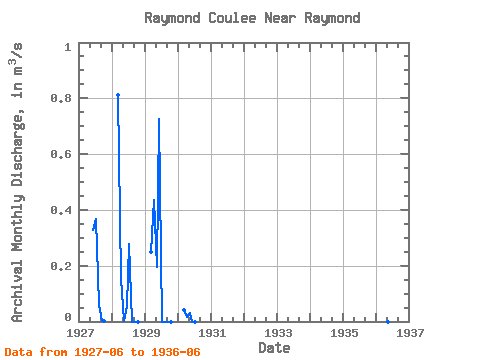
| Units: | mm |
| Year | Jan | Feb | Mar | Apr | May | Jun | Jul | Aug | Sep | Oct | Nov | Dec | Annual | 1927 | 0.33 | 0.37 | 0.06 | 0.00 | 0.00 | 1928 | 0.81 | 0.15 | 0.00 | 0.05 | 0.28 | 0.00 | 0.00 | 0.00 | 1929 | 0.25 | 0.44 | 0.20 | 0.73 | 0.00 | 0.00 | 0.00 | 0.00 | 1930 | 0.04 | 0.02 | 0.03 | 0.00 | 0.00 | 1936 | 0.14 | 0.00 | 0.00 | 0.00 |
|---|
 Return to R-Arctic Net Home Page