|
|
| Point ID: 8808 | Downloads | Plots | Site Data | Code: 12300 |
|
| Download | |
|---|---|
| Site Descriptor Information | Site Time Series Data |
| Link to all available data | |
|
|
|
| View: | Statistics | All |
| Units: | m3/s |
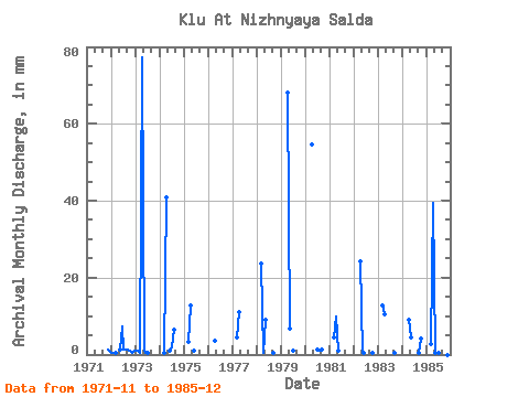
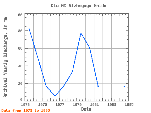
| Year | Jan | Feb | Mar | Apr | May | Jun | Jul | Aug | Sep | Oct | Nov | Dec | Annual | 1971 | 1.18 | 0.94 | 1972 | 0.47 | 0.43 | 0.47 | 1.41 | 7.28 | 1.41 | 1.41 | 1.18 | 0.94 | 0.46 | 0.94 | 1973 | 0.94 | 0.86 | 0.47 | 77.31 | 0.94 | 0.46 | 0.47 | 0.00 | 0.00 | 0.00 | 0.00 | 0.00 | 82.59 | 1974 | 0.00 | 0.00 | 0.47 | 40.93 | 0.00 | 0.73 | 1.88 | 6.39 | 0.00 | 0.00 | 0.00 | 0.00 | 50.66 | 1975 | 0.00 | 0.00 | 3.10 | 12.73 | 0.00 | 0.91 | 0.00 | 0.00 | 0.00 | 0.00 | 0.00 | 0.00 | 16.89 | 1976 | 0.00 | 0.00 | 0.00 | 3.64 | 0.00 | 0.00 | 0.00 | 0.00 | 0.00 | 0.00 | 0.00 | 0.00 | 3.69 | 1977 | 0.00 | 0.00 | 4.70 | 10.91 | 0.00 | 0.00 | 0.00 | 0.00 | 0.00 | 0.00 | 0.00 | 0.00 | 15.69 | 1978 | 0.00 | 0.00 | 24.43 | 0.46 | 9.21 | 0.00 | 0.00 | 0.00 | 0.46 | 0.00 | 0.00 | 0.00 | 33.96 | 1979 | 0.00 | 0.00 | 0.00 | 68.21 | 7.05 | 0.00 | 0.94 | 0.00 | 0.00 | 0.00 | 0.00 | 0.00 | 77.05 | 1980 | 0.00 | 0.00 | 0.00 | 54.57 | 0.00 | 0.00 | 1.41 | 0.75 | 1.18 | 0.00 | 0.00 | 0.00 | 58.51 | 1981 | 0.00 | 0.00 | 4.70 | 10.00 | 0.94 | 0.00 | 0.00 | 0.00 | 0.00 | 0.00 | 0.00 | 0.00 | 15.69 | 1982 | 0.00 | 0.00 | 0.00 | 24.10 | 0.47 | 0.46 | 0.00 | 0.00 | 0.00 | 0.47 | 0.00 | 0.00 | 25.84 | 1983 | 0.00 | 0.00 | 13.15 | 10.46 | 0.00 | 0.00 | 0.00 | 0.00 | 0.46 | 0.00 | 0.00 | 0.00 | 23.99 | 1984 | 0.00 | 0.00 | 0.00 | 9.10 | 4.70 | 0.00 | 0.00 | 0.00 | 0.46 | 4.23 | 0.00 | 0.00 | 18.46 | 1985 | 0.00 | 0.00 | 2.82 | 39.56 | 0.47 | 0.00 | 0.47 | 0.00 | 0.00 | 0.47 | 0.00 | 0.00 | 44.30 |
|---|
 Return to R-Arctic Net Home Page