|
|
| Point ID: 511 | Downloads | Plots | Site Data | Code: 05ED001 |
|
| Download | |
|---|---|
| Site Descriptor Information | Site Time Series Data |
| Link to all available data | |
|
|
|
| View: | Statistics | All |
| Units: | m3/s |
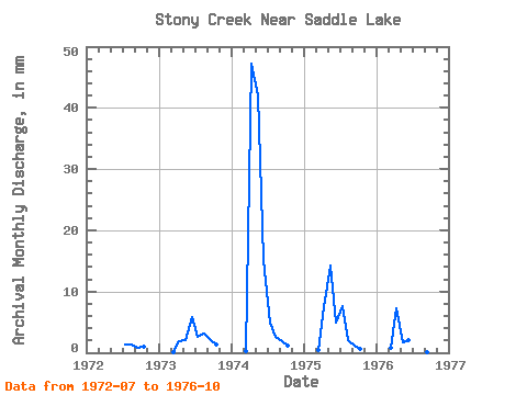
| Year | Jan | Feb | Mar | Apr | May | Jun | Jul | Aug | Sep | Oct | Nov | Dec | Annual | 1972 | 0.54 | 0.55 | 0.34 | 0.41 | 1973 | 0.05 | 0.79 | 0.88 | 2.36 | 1.06 | 1.28 | 0.92 | 0.57 | 1974 | 0.12 | 18.90 | 17.36 | 6.06 | 2.03 | 1.04 | 0.77 | 0.50 | 1975 | 0.15 | 2.94 | 5.92 | 1.95 | 3.12 | 0.86 | 0.49 | 0.24 | 1976 | 0.31 | 2.88 | 0.70 | 0.83 | 0.76 | 0.18 | 0.06 | 0.08 |
|---|
 Return to R-Arctic Net Home Page