|
|
| Point ID: 2791 | Downloads | Plots | Site Data | Code: 05KK007 |
|
| Download | |
|---|---|
| Site Descriptor Information | Site Time Series Data |
| Link to all available data | |
|
|
|
| View: | Statistics | All |
| Units: | m3/s |
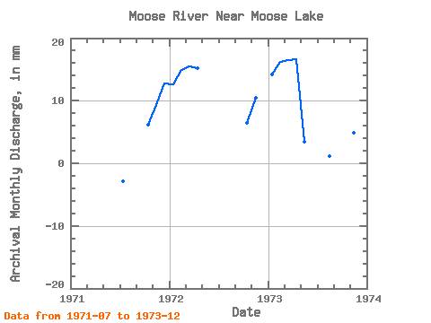
| Year | Jan | Feb | Mar | Apr | May | Jun | Jul | Aug | Sep | Oct | Nov | Dec | Annual | 1971 | -2.95 | -11.74 | -1.65 | 6.42 | 9.27 | 13.11 | 1972 | 13.00 | 14.02 | 15.97 | 15.15 | -2.45 | -0.53 | -13.20 | -13.05 | -2.04 | 6.72 | 10.40 | 1973 | 14.66 | 15.25 | 17.03 | 16.68 | 3.62 | -11.70 | -11.33 | 1.18 | -4.24 | -8.64 | 4.92 | 10.89 | 49.08 |
|---|
 Return to R-Arctic Net Home Page