|
|
|||||||||||||||||
| Point ID: 6578 | Downloads | Plots | Site Data | Code: 9257 |
|
|
|||||||||||||||||
| Download | |
|---|---|
| Site Descriptor Information | Site Time Series Data |
| Link to all available data | |

|
|
| View: | Statistics | Time Series |
| Units: | mm |
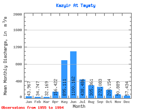
| Statistic | Jan | Feb | Mar | Apr | May | Jun | Jul | Aug | Sep | Oct | Nov | Dec | Annual |
|---|---|---|---|---|---|---|---|---|---|---|---|---|---|
| Mean | 43.97 | 34.75 | 32.17 | 156.42 | 895.11 | 1100.16 | 438.49 | 305.36 | 272.08 | 200.15 | 90.89 | 57.43 | 302.01 |
| Standard Deviation | 7.35 | 6.03 | 5.99 | 79.95 | 217.36 | 344.30 | 128.43 | 120.56 | 129.05 | 89.13 | 23.07 | 10.80 | 50.36 |
| Min | 30.10 | 22.30 | 22.00 | 40.90 | 605.00 | 479.00 | 235.00 | 127.00 | 92.00 | 81.80 | 56.30 | 38.20 | 215.06 |
| Max | 61.20 | 47.50 | 50.90 | 356.00 | 1580.00 | 2210.00 | 749.00 | 614.00 | 745.00 | 548.00 | 134.00 | 77.20 | 420.86 |
| Coefficient of Variation | 0.17 | 0.17 | 0.19 | 0.51 | 0.24 | 0.31 | 0.29 | 0.40 | 0.47 | 0.45 | 0.25 | 0.19 | 0.17 |
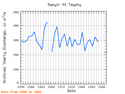
| Year | Jan | Feb | Mar | Apr | May | Jun | Jul | Aug | Sep | Oct | Nov | Dec | Annual | 1955 | 1300.00 | 478.00 | 322.00 | 562.00 | 281.00 | 95.60 | 38.20 | 1956 | 35.30 | 23.90 | 27.80 | 106.00 | 870.00 | 879.00 | 412.00 | 260.00 | 443.00 | 267.00 | 113.00 | 52.90 | 290.82 | 1957 | 38.90 | 30.60 | 29.10 | 76.90 | 605.00 | 1160.00 | 304.00 | 435.00 | 302.00 | 282.00 | 125.00 | 73.70 | 288.52 | 1958 | 53.90 | 43.30 | 33.40 | 137.00 | 873.00 | 1370.00 | 379.00 | 223.00 | 213.00 | 148.00 | 73.20 | 44.20 | 299.25 | 1959 | 37.40 | 34.60 | 34.30 | 214.00 | 1110.00 | 1290.00 | 509.00 | 192.00 | 184.00 | 187.00 | 82.00 | 55.00 | 327.44 | 1960 | 46.40 | 39.80 | 35.00 | 153.00 | 765.00 | 1100.00 | 422.00 | 614.00 | 393.00 | 170.00 | 128.00 | 70.90 | 328.09 | 1961 | 52.00 | 44.20 | 40.40 | 356.00 | 1120.00 | 1120.00 | 524.00 | 245.00 | 403.00 | 213.00 | 105.00 | 66.30 | 357.41 | 1962 | 51.40 | 41.40 | 37.60 | 218.00 | 1170.00 | 817.00 | 338.00 | 197.00 | 202.00 | 215.00 | 101.00 | 66.80 | 287.93 | 1963 | 49.70 | 41.70 | 39.10 | 82.00 | 762.00 | 1070.00 | 444.00 | 229.00 | 212.00 | 131.00 | 95.20 | 54.50 | 267.52 | 1964 | 45.50 | 27.20 | 24.60 | 82.40 | 988.00 | 740.00 | 235.00 | 218.00 | 238.00 | 112.00 | 74.80 | 52.10 | 236.47 | 1965 | 49.60 | 39.40 | 39.60 | 167.00 | 1580.00 | 819.00 | 365.00 | 319.00 | 745.00 | 295.00 | 134.00 | 77.20 | 385.82 | 1966 | 61.20 | 47.50 | 42.20 | 75.10 | 1100.00 | 2210.00 | 637.00 | 404.00 | 224.00 | 131.00 | 70.60 | 47.70 | 420.86 | 1967 | 40.30 | 36.10 | 34.20 | 315.00 | 917.00 | 726.00 | 354.00 | 254.00 | 264.00 | 1968 | 48.00 | 35.90 | 34.90 | 202.00 | 862.00 | 623.00 | 241.00 | 190.00 | 210.00 | 162.00 | 65.30 | 47.80 | 226.82 | 1969 | 36.40 | 28.40 | 25.50 | 129.00 | 990.00 | 1510.00 | 356.00 | 267.00 | 344.00 | 281.00 | 118.00 | 71.60 | 346.41 | 1970 | 52.40 | 34.80 | 28.20 | 131.00 | 1100.00 | 1500.00 | 635.00 | 429.00 | 350.00 | 308.00 | 97.60 | 60.00 | 393.83 | 1971 | 42.30 | 32.00 | 31.50 | 229.00 | 797.00 | 700.00 | 458.00 | 239.00 | 195.00 | 131.00 | 74.30 | 45.00 | 247.84 | 1972 | 35.70 | 27.60 | 25.50 | 277.00 | 666.00 | 1140.00 | 552.00 | 394.00 | 309.00 | 181.00 | 96.50 | 63.20 | 313.96 | 1973 | 48.30 | 35.00 | 32.30 | 175.00 | 698.00 | 1810.00 | 649.00 | 279.00 | 143.00 | 105.00 | 61.20 | 51.90 | 340.64 | 1974 | 42.20 | 30.00 | 26.10 | 263.00 | 880.00 | 962.00 | 254.00 | 127.00 | 174.00 | 201.00 | 83.60 | 59.80 | 258.56 | 1975 | 48.60 | 36.70 | 30.60 | 86.30 | 794.00 | 1600.00 | 496.00 | 251.00 | 282.00 | 144.00 | 64.80 | 53.10 | 323.93 | 1976 | 42.70 | 37.30 | 25.70 | 84.40 | 609.00 | 817.00 | 437.00 | 505.00 | 228.00 | 154.00 | 75.90 | 41.20 | 254.77 | 1977 | 30.10 | 26.60 | 28.60 | 208.00 | 725.00 | 1210.00 | 444.00 | 297.00 | 247.00 | 266.00 | 113.00 | 72.20 | 305.62 | 1978 | 45.30 | 36.50 | 30.90 | 146.00 | 680.00 | 1340.00 | 382.00 | 287.00 | 105.00 | 81.80 | 59.00 | 47.90 | 270.12 | 1979 | 33.40 | 27.10 | 22.70 | 58.40 | 1050.00 | 1050.00 | 256.00 | 160.00 | 278.00 | 165.00 | 101.00 | 75.80 | 273.12 | 1980 | 54.00 | 42.20 | 34.10 | 112.00 | 1100.00 | 1250.00 | 493.00 | 599.00 | 284.00 | 135.00 | 84.30 | 57.00 | 353.72 | 1981 | 42.20 | 38.60 | 36.40 | 305.00 | 790.00 | 479.00 | 297.00 | 205.00 | 206.00 | 193.00 | 66.80 | 54.60 | 226.13 | 1982 | 43.50 | 38.60 | 38.70 | 176.00 | 1130.00 | 814.00 | 405.00 | 190.00 | 147.00 | 254.00 | 133.00 | 71.30 | 286.76 | 1983 | 51.30 | 37.30 | 32.70 | 40.90 | 700.00 | 1220.00 | 569.00 | 300.00 | 207.00 | 297.00 | 119.00 | 60.60 | 302.90 | 1984 | 47.40 | 38.00 | 30.80 | 47.50 | 627.00 | 885.00 | 511.00 | 331.00 | 148.00 | 259.00 | 124.00 | 60.50 | 259.10 | 1985 | 37.50 | 30.70 | 27.80 | 104.00 | 660.00 | 1300.00 | 606.00 | 386.00 | 436.00 | 163.00 | 72.90 | 42.30 | 322.18 | 1986 | 31.90 | 22.30 | 22.00 | 64.30 | 1080.00 | 875.00 | 452.00 | 451.00 | 221.00 | 148.00 | 85.70 | 56.90 | 292.51 | 1987 | 33.90 | 30.20 | 29.80 | 134.00 | 1190.00 | 1070.00 | 602.00 | 351.00 | 339.00 | 548.00 | 88.20 | 61.40 | 373.12 | 1988 | 50.60 | 36.90 | 29.50 | 210.00 | 794.00 | 1060.00 | 749.00 | 462.00 | 206.00 | 128.00 | 75.80 | 57.30 | 321.59 | 1989 | 44.20 | 34.50 | 32.90 | 143.00 | 801.00 | 780.00 | 318.00 | 151.00 | 92.00 | 88.60 | 56.30 | 39.20 | 215.06 | 1993 | 35.30 | 27.50 | 50.90 | 198.00 | 631.00 | 1130.00 | 365.00 | 230.00 | 259.00 | 180.00 | 67.50 | 60.10 | 269.52 | 1994 | 44.00 | 36.50 | 32.70 | 125.00 | 1010.00 | 980.00 | 296.00 |
|---|
 Return to R-Arctic Net Home Page